Jimai geodata
Jimai (Qinghai) is a seat of a third-order administrative division; located in China in Asia/Shanghai (GMT+8) time zone. In our database, there are 1268 cities with bigger population. Compared to other cities in China, 69% of cities are located further ↓South; 94.8% of cities are located further →East and 98.6% of cities have lower elevation than Jimai. Note1


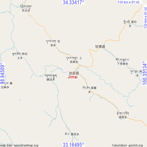
Jimai GPS coordinates[2]
33° 45' 5.58" North, 99° 38' 53.556" East
| Map corner | latitude | longitude |
|---|---|---|
| Upper-left | 34.33417°, | 98.94509° |
| Center: | 33.75155°, | 99.64821° |
| Lower-right: | 33.16495°, | 100.35134° |
| Map W x H: | 130×130 km | = 80.8×80.8mi |
| max Lat: | 53.31946° ⇑31% North |
| Jimai: | 33.75155° |
| min Lat: | ⇓69% South 18.22056° |
| min Long | Jimai | max Long |
| 75.07348° | 99.64821° | 134.28917° |
| W 5.2%⇐ | ⇒94.8% E |
Elevation
Elevation of Jimai is 3981 m = 13061 ft, and this is 3496.2 m = 11470 ft above average elevation for this country.
| Max E: |
5622 m = 18445 ft | 1.4% |
| Jimai | 3981 m 13061 ft | |
| Avg. | 484.8 m = 1591 ft | |
Min E: |
-3 m = -10 ft | 98.6% |
See also: China elevation on elevation.city.
Geographical zone
Jimai is located in North temperate zone (between Tropic of Cancer and the Arctic Circle). Distance of this Northern Tropic circle is 1146.9 km =712.7 mi to South.| Distance of | km | miles | from Jimai |
|---|---|---|---|
| North Pole | 6254.2 | 3886.2 | to North |
| Arctic Circle | 3648.4 | 2267 | to North |
| Tropic Cancer | 1146.9 | 712.7 | to South |
| Equator | 3752.8 | 2331.9 | to South |


Nearby cities:
15 places around Jimai: (largest is in red/bold)
• Dêrnang
59.6 km =37 mi,  126°
126°
• Ganglong
56.2 km =34.9 mi,  88°
88°
• Gyangqai
83.3 km =51.8 mi,  56°
56°
• Jianshe
24.2 km =15 mi,  251°
251°
• Kequ
33.6 km =20.9 mi,  44°
44°
• Kyinzhi
66.5 km =41.3 mi,  48°
48°
• Marzhing
85.9 km =53.4 mi, 125°
• Moba
53.7 km =33.4 mi,  181°
181°
• Sangruma
43 km =26.7 mi, 254°
• Shanggongma
9.3 km =5.8 mi,  10°
10°
• Tanglag
33.1 km =20.6 mi,  325°
325°
• Tehetu
50.4 km =31.3 mi,  288°
288°
• Wosai
20.5 km =12.7 mi,  136°
136°
• Xiagongma
48.3 km =30 mi,  84°
84°
• Youyun
71.5 km =44.4 mi,  323°
323°
Sources, notices
• [Note1] Compared only with cities in China existing in our database
• [Src1] Map data: © OpenStreetMap contributors (CC-BY-SA)
• [Src2] Other city data from geonames.org with taken over terms of usage.
• [Src3] Geographical zone / Annual Mean Temperature by Robert A. Rohde @ Wikipedia
