Danzhaolu geodata
Danzhaolu (Hubei) is a seat of a fourth-order administrative division; located in China in Asia/Shanghai (GMT+8) time zone. In our database, there are 1268 cities with bigger population. Compared to other cities in China, 64.2% of cities are located further ↓South; 64.9% of cities are located further →East and 53.8% of cities have higher elevation than Danzhaolu. Note1


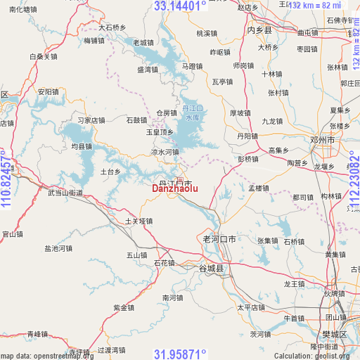
Danzhaolu GPS coordinates[2]
32° 33' 11.952" North, 111° 31' 39.684" East
| Map corner | latitude | longitude |
|---|---|---|
| Upper-left | 33.14401°, | 110.82457° |
| Center: | 32.55332°, | 111.52769° |
| Lower-right: | 31.95871°, | 112.23082° |
| Map W x H: | 131.8×131.8 km | = 81.9×81.9mi |
| max Lat: | 53.31946° ⇑35.8% North |
| Danzhaolu: | 32.55332° |
| min Lat: | ⇓64.2% South 18.22056° |
| min Long | Danzhaolu | max Long |
| 75.07348° | 111.52769° | 134.28917° |
| W 35.1%⇐ | ⇒64.9% E |
Elevation
Elevation of Danzhaolu is 138 m = 453 ft, and this is 346.8 m = 1138 ft below average elevation for this country.
| Max E: |
5622 m = 18445 ft | 53.8% |
| Avg. | 484.8 m = 1591 ft | |
| Danzhaolu | 138 m = 453 ft | |
Min E: |
-3 m = -10 ft | 46.2% |
See also: China elevation on elevation.city.
Geographical zone
Danzhaolu is located in North temperate zone (between Tropic of Cancer and the Arctic Circle). Distance of this Northern Tropic circle is 1013.7 km =629.9 mi to South.| Distance of | km | miles | from Danzhaolu |
|---|---|---|---|
| North Pole | 6387.5 | 3969 | to North |
| Arctic Circle | 3781.6 | 2349.8 | to North |
| Tropic Cancer | 1013.7 | 629.9 | to South |
| Equator | 3619.6 | 2249.1 | to South |


Nearby cities:
15 places around Danzhaolu: (largest is in red/bold)
• Danjiangkou
2.1 km =1.3 mi,  236°
236°
• Haoping
33 km =20.5 mi,  310°
310°
• Hongshanzui
16.6 km =10.3 mi,  131°
131°
• Langhe
28.9 km =18 mi, 240°
• Laohekou
22.8 km =14.2 mi,  144°
144°
• Lengji
21.6 km =13.4 mi,  163°
163°
• Liangshuihe
11.8 km =7.3 mi,  330°
330°
• Sanguandian
5.9 km =3.7 mi,  223°
223°
• Shigu
27.4 km =17 mi,  324°
324°
• Shihua
31.3 km =19.4 mi,  192°
192°
• Tuguanya
21.3 km =13.2 mi,  226°
226°
• Tutai
25.4 km =15.8 mi,  278°
278°
• Wushan
31.7 km =19.7 mi,  210°
210°
• Yuanchong
19.6 km =12.2 mi,  98°
98°
• Yuhuangding
19.4 km =12.1 mi,  336°
336°
Sources, notices
• [Note1] Compared only with cities in China existing in our database
• [Src1] Map data: © OpenStreetMap contributors (CC-BY-SA)
• [Src2] Other city data from geonames.org with taken over terms of usage.
• [Src3] Geographical zone / Annual Mean Temperature by Robert A. Rohde @ Wikipedia
