Danjiangkou geodata
Danjiangkou (Hubei) is a populated place; located in China in Asia/Shanghai (GMT+8) time zone. With population of 92,008 people, there are 458 cities with bigger population in this country. Compared to other cities in China, 64.2% of cities are located further ↓South; 65% of cities are located further →East and 58.5% of cities have higher elevation than Danjiangkou. Note1


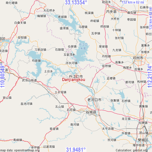
Danjiangkou GPS coordinates[2]
32° 32' 34.008" North, 111° 30' 30.996" East
| Map corner | latitude | longitude |
|---|---|---|
| Upper-left | 33.13354°, | 110.80549° |
| Center: | 32.54278°, | 111.50861° |
| Lower-right: | 31.9481°, | 112.21174° |
| Map W x H: | 131.8×131.8 km | = 81.9×81.9mi |
| max Lat: | 53.31946° ⇑35.8% North |
| Danjiangkou: | 32.54278° |
| min Lat: | ⇓64.2% South 18.22056° |
| min Long | Danjiangkou | max Long |
| 75.07348° | 111.50861° | 134.28917° |
| W 35%⇐ | ⇒65% E |
Elevation
Elevation of Danjiangkou is 108 m = 354 ft, and this is 376.8 m = 1236 ft below average elevation for this country.
| Max E: |
5622 m = 18445 ft | 58.5% |
| Avg. | 484.8 m = 1591 ft | |
| Danjiangkou | 108 m = 354 ft | |
Min E: |
-3 m = -10 ft | 41.5% |
See also: Danjiangkou elevation on elevation.city.
Geographical zone
Danjiangkou is located in North temperate zone (between Tropic of Cancer and the Arctic Circle). Distance of this Northern Tropic circle is 1012.5 km =629.1 mi to South.| Distance of | km | miles | from Danjiangkou |
|---|---|---|---|
| North Pole | 6388.6 | 3969.7 | to North |
| Arctic Circle | 3782.8 | 2350.5 | to North |
| Tropic Cancer | 1012.5 | 629.1 | to South |
| Equator | 3618.4 | 2248.4 | to South |


Nearby cities:
15 places around Danjiangkou: (largest is in red/bold)
• Danzhaolu
2.1 km =1.3 mi,  56°
56°
• Haoping
32.4 km =20.1 mi,  313°
313°
• Hongshanzui
17.3 km =10.7 mi,  124°
124°
• Langhe
26.7 km =16.6 mi,  240°
240°
• Laohekou
23 km =14.3 mi,  139°
139°
• Lengji
21 km =13 mi,  157°
157°
• Liangshuihe
12.2 km =7.6 mi,  340°
340°
• Sanguandian
3.9 km =2.4 mi,  215°
215°
• Shigu
27.4 km =17 mi,  328°
328°
• Shihua
29.8 km =18.5 mi,  189°
189°
• Tuguanya
19.2 km =11.9 mi, 224°
• Tutai
23.8 km =14.8 mi,  282°
282°
• Wushan
29.8 km =18.5 mi,  208°
208°
• Yuanchong
21.2 km =13.2 mi,  94°
94°
• Yuhuangding
19.9 km =12.4 mi, 342°
Sources, notices
• [Note1] Compared only with cities in China existing in our database
• [Src1] Map data: © OpenStreetMap contributors (CC-BY-SA)
• [Src2] Other city data from geonames.org with taken over terms of usage.
• [Src3] Geographical zone / Annual Mean Temperature by Robert A. Rohde @ Wikipedia
