Yelang geodata
Yelang (Guizhou) is a seat of a fourth-order administrative division; located in China in Asia/Shanghai (GMT+8) time zone. With population of 320 people, there are 1267 cities with bigger population in this country. Compared to other cities in China, 70.6% of cities are located further ↑North; 84.3% of cities are located further →East and 77% of cities have lower elevation than Yelang. Note1


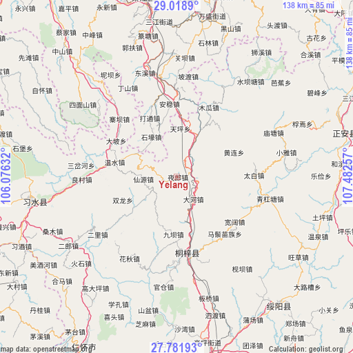
Yelang GPS coordinates[2]
28° 24' 7.992" North, 106° 46' 45.984" East
| Map corner | latitude | longitude |
|---|---|---|
| Upper-left | 29.0189°, | 106.07632° |
| Center: | 28.40222°, | 106.77944° |
| Lower-right: | 27.78193°, | 107.48257° |
| Map W x H: | 137.5×137.5 km | = 85.4×85.4mi |
| max Lat: | 53.31946° ⇑70.6% North |
| Yelang: | 28.40222° |
| min Lat: | ⇓29.4% South 18.22056° |
| min Long | Yelang | max Long |
| 75.07348° | 106.77944° | 134.28917° |
| W 15.7%⇐ | ⇒84.3% E |
Elevation
Elevation of Yelang is 576 m = 1890 ft, and this is 91.2 m = 299 ft above average elevation for this country.
| Max E: |
5622 m = 18445 ft | 23% |
| Yelang | 576 m 1890 ft | |
| Avg. | 484.8 m = 1591 ft | |
Min E: |
-3 m = -10 ft | 77% |
See also: China elevation on elevation.city.
Geographical zone
Yelang is located in North temperate zone (between Tropic of Cancer and the Arctic Circle). Distance of this Northern Tropic circle is 552.1 km =343.1 mi to South.| Distance of | km | miles | from Yelang |
|---|---|---|---|
| North Pole | 6849 | 4255.8 | to North |
| Arctic Circle | 4243.1 | 2636.5 | to North |
| Tropic Cancer | 552.1 | 343.1 | to South |
| Equator | 3158 | 1962.3 | to South |


Nearby cities:
15 places around Yelang: (largest is in red/bold)
• Anwen
31 km =19.3 mi,  355°
355°
• Chumi
19.5 km =12.1 mi,  164°
164°
• Dahe
10.3 km =6.4 mi,  147°
147°
• Datong
24.2 km =15 mi,  333°
333°
• Guandian
20.4 km =12.7 mi,  233°
233°
• Huanglian
24.3 km =15.1 mi,  66°
66°
• Huangyang
31.2 km =19.4 mi,  112°
112°
• Liziba
22.8 km =14.2 mi,  184°
184°
• Loushanguan
29.8 km =18.5 mi,  171°
171°
• Songkan
18.2 km =11.3 mi,  25°
25°
• Taibai
30.1 km =18.7 mi,  88°
88°
• Wenshui
25.3 km =15.7 mi,  282°
282°
• Xianyuan
17.7 km =11 mi,  263°
263°
• Xinzhan
7.7 km =4.8 mi,  101°
101°
• Zhaiba
31.2 km =19.4 mi,  315°
315°
Sources, notices
• [Note1] Compared only with cities in China existing in our database
• [Src1] Map data: © OpenStreetMap contributors (CC-BY-SA)
• [Src2] Other city data from geonames.org with taken over terms of usage.
• [Src3] Geographical zone / Annual Mean Temperature by Robert A. Rohde @ Wikipedia
