Wenshui geodata
Wenshui (Guizhou) is a seat of a fourth-order administrative division; located in China in Asia/Shanghai (GMT+8) time zone. With population of 5,531 people, there are 857 cities with bigger population in this country. Compared to other cities in China, 70.1% of cities are located further ↑North; 85.1% of cities are located further →East and 85.9% of cities have lower elevation than Wenshui. Note1


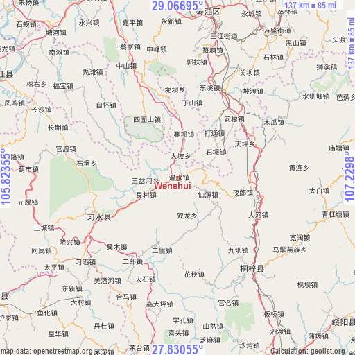
Wenshui GPS coordinates[2]
28° 27' 2.016" North, 106° 31' 36.012" East
| Map corner | latitude | longitude |
|---|---|---|
| Upper-left | 29.06695°, | 105.82355° |
| Center: | 28.45056°, | 106.52667° |
| Lower-right: | 27.83055°, | 107.2298° |
| Map W x H: | 137.5×137.5 km | = 85.4×85.4mi |
| max Lat: | 53.31946° ⇑70.1% North |
| Wenshui: | 28.45056° |
| min Lat: | ⇓29.9% South 18.22056° |
| min Long | Wenshui | max Long |
| 75.07348° | 106.52667° | 134.28917° |
| W 14.9%⇐ | ⇒85.1% E |
Elevation
Elevation of Wenshui is 1039 m = 3409 ft, and this is 554.2 m = 1818 ft above average elevation for this country.
| Max E: |
5622 m = 18445 ft | 14.1% |
| Wenshui | 1039 m 3409 ft | |
| Avg. | 484.8 m = 1591 ft | |
Min E: |
-3 m = -10 ft | 85.9% |
See also: China elevation on elevation.city.
Geographical zone
Wenshui is located in North temperate zone (between Tropic of Cancer and the Arctic Circle). Distance of this Northern Tropic circle is 557.5 km =346.4 mi to South.| Distance of | km | miles | from Wenshui |
|---|---|---|---|
| North Pole | 6843.7 | 4252.5 | to North |
| Arctic Circle | 4237.8 | 2633.2 | to North |
| Tropic Cancer | 557.5 | 346.4 | to South |
| Equator | 3163.4 | 1965.6 | to South |


Nearby cities:
15 places around Wenshui: (largest is in red/bold)
• Anwen
34 km =21.1 mi,  41°
41°
• Bailin
32.4 km =20.1 mi,  348°
348°
• Dahe
33.4 km =20.8 mi,  114°
114°
• Datong
21.3 km =13.2 mi, 40°
• Donghuang
33.1 km =20.6 mi,  246°
246°
• Guandian
19.3 km =12 mi,  154°
154°
• Liangcunchang
11.1 km =6.9 mi,  243°
243°
• Sanchahe
10.8 km =6.7 mi,  297°
297°
• Sangmu
36.3 km =22.6 mi,  223°
223°
• Songkan
34.4 km =21.4 mi,  71°
71°
• Xianyuan
10.4 km =6.5 mi,  136°
136°
• Xinzhan
33 km =20.5 mi,  102°
102°
• Yelang
25.3 km =15.7 mi, 102°
• Yong’an
29.2 km =18.1 mi,  199°
199°
• Zhaiba
17.2 km =10.7 mi,  9°
9°
Sources, notices
• [Note1] Compared only with cities in China existing in our database
• [Src1] Map data: © OpenStreetMap contributors (CC-BY-SA)
• [Src2] Other city data from geonames.org with taken over terms of usage.
• [Src3] Geographical zone / Annual Mean Temperature by Robert A. Rohde @ Wikipedia
