Xianyuan geodata
Xianyuan (Guizhou) is a seat of a fourth-order administrative division; located in China in Asia/Shanghai (GMT+8) time zone. In our database, there are 1268 cities with bigger population. Compared to other cities in China, 70.8% of cities are located further ↑North; 84.8% of cities are located further →East and 90.3% of cities have lower elevation than Xianyuan. Note1


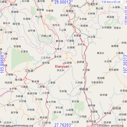
Xianyuan GPS coordinates[2]
28° 22' 59.988" North, 106° 36' 0" East
| Map corner | latitude | longitude |
|---|---|---|
| Upper-left | 29.00012°, | 105.89688° |
| Center: | 28.38333°, | 106.6° |
| Lower-right: | 27.76293°, | 107.30313° |
| Map W x H: | 137.6×137.6 km | = 85.5×85.5mi |
| max Lat: | 53.31946° ⇑70.8% North |
| Xianyuan: | 28.38333° |
| min Lat: | ⇓29.2% South 18.22056° |
| min Long | Xianyuan | max Long |
| 75.07348° | 106.6° | 134.28917° |
| W 15.2%⇐ | ⇒84.8% E |
Elevation
Elevation of Xianyuan is 1386 m = 4547 ft, and this is 901.2 m = 2957 ft above average elevation for this country.
| Max E: |
5622 m = 18445 ft | 9.7% |
| Xianyuan | 1386 m 4547 ft | |
| Avg. | 484.8 m = 1591 ft | |
Min E: |
-3 m = -10 ft | 90.3% |
See also: China elevation on elevation.city.
Geographical zone
Xianyuan is located in North temperate zone (between Tropic of Cancer and the Arctic Circle). Distance of this Northern Tropic circle is 550 km =341.8 mi to South.| Distance of | km | miles | from Xianyuan |
|---|---|---|---|
| North Pole | 6851.1 | 4257.1 | to North |
| Arctic Circle | 4245.2 | 2637.8 | to North |
| Tropic Cancer | 550 | 341.8 | to South |
| Equator | 3155.9 | 1961 | to South |


Nearby cities:
15 places around Xianyuan: (largest is in red/bold)
• Chumi
28.2 km =17.5 mi,  126°
126°
• Dahe
24.1 km =15 mi,  105°
105°
• Datong
24.6 km =15.3 mi,  15°
15°
• Guandian
10 km =6.2 mi,  173°
173°
• Huaqiu
29.7 km =18.5 mi,  179°
179°
• Liangcunchang
17.4 km =10.8 mi,  278°
278°
• Liziba
26.1 km =16.2 mi,  142°
142°
• Loushanguan
35 km =21.7 mi, 141°
• Sanchahe
20.9 km =13 mi,  306°
306°
• Songkan
31.4 km =19.5 mi,  53°
53°
• Wenshui
10.4 km =6.5 mi,  316°
316°
• Xinzhan
25.1 km =15.6 mi,  88°
88°
• Yelang
17.7 km =11 mi,  83°
83°
• Yong’an
26.4 km =16.4 mi,  220°
220°
• Zhaiba
24.8 km =15.4 mi,  349°
349°
Sources, notices
• [Note1] Compared only with cities in China existing in our database
• [Src1] Map data: © OpenStreetMap contributors (CC-BY-SA)
• [Src2] Other city data from geonames.org with taken over terms of usage.
• [Src3] Geographical zone / Annual Mean Temperature by Robert A. Rohde @ Wikipedia
