Dêqên geodata
Dêqên (Tibet) is a populated place; located in China in Asia/Shanghai (GMT+8) time zone. With population of 62,400 people, there are 689 cities with bigger population in this country. Compared to other cities in China, 54.4% of cities are located further ↑North; 97% of cities are located further →East and 98.6% of cities have lower elevation than Dêqên. Note1


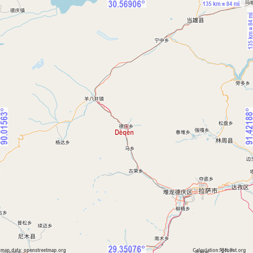
Dêqên GPS coordinates[2]
29° 57' 42.408" North, 90° 43' 7.5" East
| Map corner | latitude | longitude |
|---|---|---|
| Upper-left | 30.56906°, | 90.01563° |
| Center: | 29.96178°, | 90.71875° |
| Lower-right: | 29.35076°, | 91.42188° |
| Map W x H: | 135.5×135.5 km | = 84.2×84.2mi |
| max Lat: | 53.31946° ⇑54.4% North |
| Dêqên: | 29.96178° |
| min Lat: | ⇓45.6% South 18.22056° |
| min Long | Dêqên | max Long |
| 75.07348° | 90.71875° | 134.28917° |
| W 3%⇐ | ⇒97% E |
Elevation
Elevation of Dêqên is 3974 m = 13038 ft, and this is 3489.2 m = 11448 ft above average elevation for this country.
| Max E: |
5622 m = 18445 ft | 1.4% |
| Dêqên | 3974 m 13038 ft | |
| Avg. | 484.8 m = 1591 ft | |
Min E: |
-3 m = -10 ft | 98.6% |
See also: Dêqên elevation on elevation.city.
Geographical zone
Dêqên is located in North temperate zone (between Tropic of Cancer and the Arctic Circle). Distance of this Northern Tropic circle is 725.5 km =450.8 mi to South.| Distance of | km | miles | from Dêqên |
|---|---|---|---|
| North Pole | 6675.6 | 4148 | to North |
| Arctic Circle | 4069.7 | 2528.8 | to North |
| Tropic Cancer | 725.5 | 450.8 | to South |
| Equator | 3331.4 | 2070 | to South |


Nearby cities:
15 places around Dêqên: (largest is in red/bold)
• Caina
62.3 km =38.7 mi,  158°
158°
• Chaqi
102.9 km =63.9 mi,  140°
140°
• Dagar
69.5 km =43.2 mi,  182°
182°
• Deqing
84.9 km =52.8 mi,  317°
317°
• Dongla
98.7 km =61.3 mi, 178°
• Jibenggang
51.9 km =32.2 mi,  130°
130°
• Kangxung
96.7 km =60.1 mi,  219°
219°
• Karru
90.8 km =56.4 mi, 221°
• Konggar
78.7 km =48.9 mi, 160°
• Lhasa
50.5 km =31.4 mi, 133°
• Nam
58.5 km =36.4 mi, 159°
• Niu
53.1 km =33 mi,  145°
145°
• Partang
87.8 km =54.6 mi,  210°
210°
• Pusum
75.2 km =46.7 mi,  226°
226°
• Xumai
70.2 km =43.6 mi, 218°
Sources, notices
• [Note1] Compared only with cities in China existing in our database
• [Src1] Map data: © OpenStreetMap contributors (CC-BY-SA)
• [Src2] Other city data from geonames.org with taken over terms of usage.
• [Src3] Geographical zone / Annual Mean Temperature by Robert A. Rohde @ Wikipedia
