Hongwansi geodata
Hongwansi (Gansu) is a seat of a third-order administrative division; located in China in Asia/Shanghai (GMT+8) time zone. In our database, there are 1268 cities with bigger population. Compared to other cities in China, 82.4% of cities are located further ↓South; 94.8% of cities are located further →East and 96% of cities have lower elevation than Hongwansi. Note1


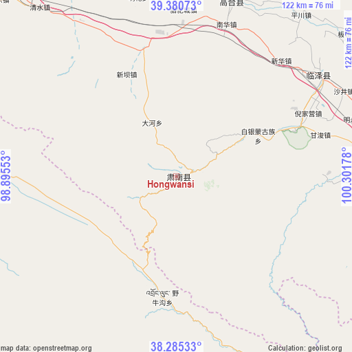
Hongwansi GPS coordinates[2]
38° 50' 6.504" North, 99° 35' 55.14" East
| Map corner | latitude | longitude |
|---|---|---|
| Upper-left | 39.38073°, | 98.89553° |
| Center: | 38.83514°, | 99.59865° |
| Lower-right: | 38.28533°, | 100.30178° |
| Map W x H: | 121.8×121.8 km | = 75.7×75.7mi |
| max Lat: | 53.31946° ⇑17.6% North |
| Hongwansi: | 38.83514° |
| min Lat: | ⇓82.4% South 18.22056° |
| min Long | Hongwansi | max Long |
| 75.07348° | 99.59865° | 134.28917° |
| W 5.2%⇐ | ⇒94.8% E |
Elevation
Elevation of Hongwansi is 2545 m = 8350 ft, and this is 2060.2 m = 6759 ft above average elevation for this country.
| Max E: |
5622 m = 18445 ft | 4% |
| Hongwansi | 2545 m 8350 ft | |
| Avg. | 484.8 m = 1591 ft | |
Min E: |
-3 m = -10 ft | 96% |
See also: China elevation on elevation.city.
Geographical zone
Hongwansi is located in North temperate zone (between Tropic of Cancer and the Arctic Circle). Distance of this Northern Tropic circle is 1712.1 km =1063.8 mi to South.| Distance of | km | miles | from Hongwansi |
|---|---|---|---|
| North Pole | 5689 | 3535 | to North |
| Arctic Circle | 3083.1 | 1915.7 | to North |
| Tropic Cancer | 1712.1 | 1063.8 | to South |
| Equator | 4318.1 | 2683.1 | to South |


Nearby cities:
15 places around Hongwansi: (largest is in red/bold)
• Baiyin
26.7 km =16.6 mi,  69°
69°
• Ganjun
51.5 km =32 mi, 73°
• Gaotai Chengguanzhen
59.3 km =36.8 mi,  17°
17°
• Hongyazi
43.8 km =27.2 mi,  324°
324°
• Kekeli
56.1 km =34.9 mi,  206°
206°
• Liaoquan
68.4 km =42.5 mi,  33°
33°
• Longqu
60.2 km =37.4 mi,  90°
90°
• Nanhua
55.9 km =34.7 mi, 16°
• Qinglong
9.9 km =6.2 mi,  58°
58°
• Shahe
60.6 km =37.7 mi, 55°
• Shajing
64.8 km =40.3 mi, 62°
• Xinba
39.6 km =24.6 mi,  335°
335°
• Xinhua
53.4 km =33.2 mi,  40°
40°
• Xishui
54.9 km =34.1 mi,  113°
113°
• Yeniugou
45.9 km =28.5 mi,  188°
188°
Sources, notices
• [Note1] Compared only with cities in China existing in our database
• [Src1] Map data: © OpenStreetMap contributors (CC-BY-SA)
• [Src2] Other city data from geonames.org with taken over terms of usage.
• [Src3] Geographical zone / Annual Mean Temperature by Robert A. Rohde @ Wikipedia
