Hongyazi geodata
Hongyazi (Gansu) is a seat of a fourth-order administrative division; located in China in Asia/Shanghai (GMT+8) time zone. In our database, there are 1268 cities with bigger population. Compared to other cities in China, 83.5% of cities are located further ↓South; 95% of cities are located further →East and 95.2% of cities have lower elevation than Hongyazi. Note1


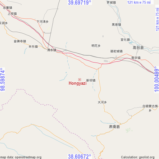
Hongyazi GPS coordinates[2]
39° 9' 14.652" North, 99° 18' 6.696" East
| Map corner | latitude | longitude |
|---|---|---|
| Upper-left | 39.69719°, | 98.59874° |
| Center: | 39.15407°, | 99.30186° |
| Lower-right: | 38.60672°, | 100.00499° |
| Map W x H: | 121.2×121.2 km | = 75.3×75.3mi |
| max Lat: | 53.31946° ⇑16.5% North |
| Hongyazi: | 39.15407° |
| min Lat: | ⇓83.5% South 18.22056° |
| min Long | Hongyazi | max Long |
| 75.07348° | 99.30186° | 134.28917° |
| W 5%⇐ | ⇒95% E |
Elevation
Elevation of Hongyazi is 2195 m = 7201 ft, and this is 1710.2 m = 5611 ft above average elevation for this country.
| Max E: |
5622 m = 18445 ft | 4.8% |
| Hongyazi | 2195 m 7201 ft | |
| Avg. | 484.8 m = 1591 ft | |
Min E: |
-3 m = -10 ft | 95.2% |
See also: China elevation on elevation.city.
Geographical zone
Hongyazi is located in North temperate zone (between Tropic of Cancer and the Arctic Circle). Distance of this Northern Tropic circle is 1747.6 km =1085.9 mi to South.| Distance of | km | miles | from Hongyazi |
|---|---|---|---|
| North Pole | 5653.5 | 3512.9 | to North |
| Arctic Circle | 3047.6 | 1893.7 | to North |
| Tropic Cancer | 1747.6 | 1085.9 | to South |
| Equator | 4353.5 | 2705.1 | to South |


Nearby cities:
15 places around Hongyazi: (largest is in red/bold)
• Baiyin
57 km =35.4 mi,  117°
117°
• Gaotai Chengguanzhen
47.8 km =29.7 mi,  63°
63°
• Heiquan
48.6 km =30.2 mi,  33°
33°
• Hongwansi
43.8 km =27.2 mi,  144°
144°
• Jinfosi
49.9 km =31 mi,  303°
303°
• Lianhua
56 km =34.8 mi,  341°
341°
• Liaoquan
66.6 km =41.4 mi,  70°
70°
• Luocheng
62.7 km =39 mi,  20°
20°
• Minghai
39.7 km =24.7 mi,  14°
14°
• Nanhua
45.2 km =28.1 mi, 66°
• Qinglong
45.6 km =28.3 mi,  131°
131°
• Qingshui
29.3 km =18.2 mi,  330°
330°
• Xiaheqing
54.2 km =33.7 mi, 327°
• Xinba
9.1 km =5.7 mi,  87°
87°
• Xinhua
60.4 km =37.5 mi, 85°
Sources, notices
• [Note1] Compared only with cities in China existing in our database
• [Src1] Map data: © OpenStreetMap contributors (CC-BY-SA)
• [Src2] Other city data from geonames.org with taken over terms of usage.
• [Src3] Geographical zone / Annual Mean Temperature by Robert A. Rohde @ Wikipedia
