Namsai geodata
Namsai (Qinghai) is a seat of a fourth-order administrative division; located in China in Asia/Shanghai (GMT+8) time zone. In our database, there are 1268 cities with bigger population. Compared to other cities in China, 65.1% of cities are located further ↓South; 96% of cities are located further →East and 98.6% of cities have lower elevation than Namsai. Note1


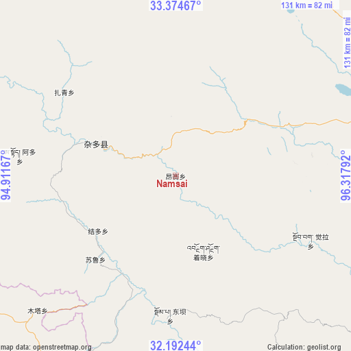
Namsai GPS coordinates[2]
32° 47' 7.872" North, 95° 36' 53.244" East
| Map corner | latitude | longitude |
|---|---|---|
| Upper-left | 33.37467°, | 94.91167° |
| Center: | 32.78552°, | 95.61479° |
| Lower-right: | 32.19244°, | 96.31792° |
| Map W x H: | 131.5×131.5 km | = 81.7×81.7mi |
| max Lat: | 53.31946° ⇑34.9% North |
| Namsai: | 32.78552° |
| min Lat: | ⇓65.1% South 18.22056° |
| min Long | Namsai | max Long |
| 75.07348° | 95.61479° | 134.28917° |
| W 4%⇐ | ⇒96% E |
Elevation
Elevation of Namsai is 3966 m = 13012 ft, and this is 3481.2 m = 11421 ft above average elevation for this country.
| Max E: |
5622 m = 18445 ft | 1.4% |
| Namsai | 3966 m 13012 ft | |
| Avg. | 484.8 m = 1591 ft | |
Min E: |
-3 m = -10 ft | 98.6% |
See also: China elevation on elevation.city.
Geographical zone
Namsai is located in North temperate zone (between Tropic of Cancer and the Arctic Circle). Distance of this Northern Tropic circle is 1039.5 km =645.9 mi to South.| Distance of | km | miles | from Namsai |
|---|---|---|---|
| North Pole | 6361.7 | 3953 | to North |
| Arctic Circle | 3755.8 | 2333.7 | to North |
| Tropic Cancer | 1039.5 | 645.9 | to South |
| Equator | 3645.4 | 2265.1 | to South |


Nearby cities:
15 places around Namsai: (largest is in red/bold)
• Aduo
55.5 km =34.5 mi,  288°
288°
• Domba
52.8 km =32.8 mi,  183°
183°
• Gaxung
80 km =49.7 mi, 177°
• Gyairong
92.6 km =57.5 mi,  54°
54°
• Gyobrag
56.1 km =34.9 mi,  115°
115°
• Jieduo
35.6 km =22.1 mi,  234°
234°
• Jinisai
87.8 km =54.6 mi,  155°
155°
• Jiqu
104.2 km =64.7 mi,  153°
153°
• Linxin
99.9 km =62.1 mi,  24°
24°
• Shanglaxiu
90.9 km =56.5 mi,  85°
85°
• Sulu
44.3 km =27.5 mi,  224°
224°
• Xangda
103.5 km =64.3 mi,  128°
128°
• Xialaxiu
94.1 km =58.5 mi,  98°
98°
• Zaqing
52.1 km =32.4 mi,  307°
307°
• Zhexiao
31.5 km =19.6 mi, 159°
Sources, notices
• [Note1] Compared only with cities in China existing in our database
• [Src1] Map data: © OpenStreetMap contributors (CC-BY-SA)
• [Src2] Other city data from geonames.org with taken over terms of usage.
• [Src3] Geographical zone / Annual Mean Temperature by Robert A. Rohde @ Wikipedia
