Sulu geodata
Sulu (Qinghai) is a seat of a fourth-order administrative division; located in China in Asia/Shanghai (GMT+8) time zone. In our database, there are 1268 cities with bigger population. Compared to other cities in China, 63.9% of cities are located further ↓South; 96% of cities are located further →East and 99.2% of cities have lower elevation than Sulu. Note1


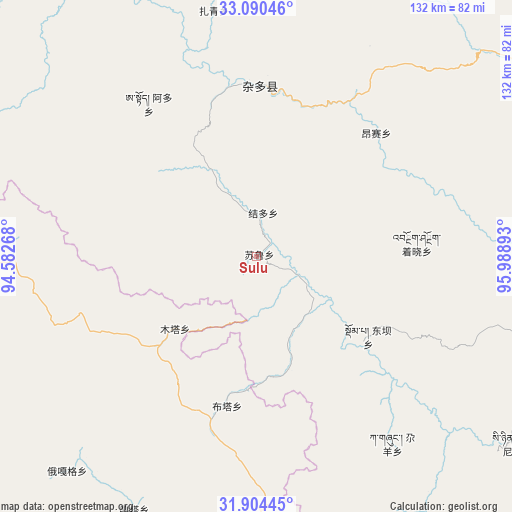
Sulu GPS coordinates[2]
32° 29' 57.876" North, 95° 17' 8.88" East
| Map corner | latitude | longitude |
|---|---|---|
| Upper-left | 33.09046°, | 94.58268° |
| Center: | 32.49941°, | 95.2858° |
| Lower-right: | 31.90445°, | 95.98893° |
| Map W x H: | 131.9×131.9 km | = 82×82mi |
| max Lat: | 53.31946° ⇑36.1% North |
| Sulu: | 32.49941° |
| min Lat: | ⇓63.9% South 18.22056° |
| min Long | Sulu | max Long |
| 75.07348° | 95.2858° | 134.28917° |
| W 4%⇐ | ⇒96% E |
Elevation
Elevation of Sulu is 4284 m = 14055 ft, and this is 3799.2 m = 12465 ft above average elevation for this country.
| Max E: |
5622 m = 18445 ft | 0.8% |
| Sulu | 4284 m 14055 ft | |
| Avg. | 484.8 m = 1591 ft | |
Min E: |
-3 m = -10 ft | 99.2% |
See also: China elevation on elevation.city.
Geographical zone
Sulu is located in North temperate zone (between Tropic of Cancer and the Arctic Circle). Distance of this Northern Tropic circle is 1007.7 km =626.2 mi to South.| Distance of | km | miles | from Sulu |
|---|---|---|---|
| North Pole | 6393.5 | 3972.7 | to North |
| Arctic Circle | 3787.6 | 2353.5 | to North |
| Tropic Cancer | 1007.7 | 626.2 | to South |
| Equator | 3613.6 | 2245.4 | to South |


Nearby cities:
15 places around Sulu: (largest is in red/bold)
• Aduo
53.7 km =33.4 mi,  335°
335°
• Dingqing
124.2 km =77.2 mi,  166°
166°
• Domba
35 km =21.7 mi,  126°
126°
• Gaxung
59.4 km =36.9 mi,  144°
144°
• Gyamotang
108.3 km =67.3 mi, 172°
• Gyobrag
81.8 km =50.8 mi,  84°
84°
• Jieduo
11.4 km =7.1 mi,  8°
8°
• Jinisai
82.8 km =51.4 mi, 125°
• Jiqu
99.2 km =61.6 mi, 128°
• Namsai
44.3 km =27.5 mi,  44°
44°
• Rongbo
121.5 km =75.5 mi,  210°
210°
• Xangda
116.7 km =72.5 mi,  106°
106°
• Ya’ngan
108.1 km =67.2 mi,  227°
227°
• Zaqing
64.2 km =39.9 mi,  350°
350°
• Zhexiao
42 km =26.1 mi,  86°
86°
Sources, notices
• [Note1] Compared only with cities in China existing in our database
• [Src1] Map data: © OpenStreetMap contributors (CC-BY-SA)
• [Src2] Other city data from geonames.org with taken over terms of usage.
• [Src3] Geographical zone / Annual Mean Temperature by Robert A. Rohde @ Wikipedia
