Gyairong geodata
Gyairong (Qinghai) is a seat of a fourth-order administrative division; located in China in Asia/Shanghai (GMT+8) time zone. In our database, there are 1268 cities with bigger population. Compared to other cities in China, 67.3% of cities are located further ↓South; 95.8% of cities are located further →East and 99% of cities have lower elevation than Gyairong. Note1


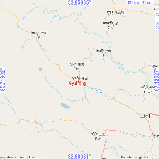
Gyairong GPS coordinates[2]
33° 16' 12.576" North, 96° 25' 19.704" East
| Map corner | latitude | longitude |
|---|---|---|
| Upper-left | 33.85605°, | 95.71902° |
| Center: | 33.27016°, | 96.42214° |
| Lower-right: | 32.68031°, | 97.12527° |
| Map W x H: | 130.7×130.7 km | = 81.2×81.2mi |
| max Lat: | 53.31946° ⇑32.7% North |
| Gyairong: | 33.27016° |
| min Lat: | ⇓67.3% South 18.22056° |
| min Long | Gyairong | max Long |
| 75.07348° | 96.42214° | 134.28917° |
| W 4.2%⇐ | ⇒95.8% E |
Elevation
Elevation of Gyairong is 4194 m = 13760 ft, and this is 3709.2 m = 12169 ft above average elevation for this country.
| Max E: |
5622 m = 18445 ft | 1% |
| Gyairong | 4194 m 13760 ft | |
| Avg. | 484.8 m = 1591 ft | |
Min E: |
-3 m = -10 ft | 99% |
See also: China elevation on elevation.city.
Geographical zone
Gyairong is located in North temperate zone (between Tropic of Cancer and the Arctic Circle). Distance of this Northern Tropic circle is 1093.4 km =679.4 mi to South.| Distance of | km | miles | from Gyairong |
|---|---|---|---|
| North Pole | 6307.8 | 3919.5 | to North |
| Arctic Circle | 3701.9 | 2300.3 | to North |
| Tropic Cancer | 1093.4 | 679.4 | to South |
| Equator | 3699.3 | 2298.6 | to South |


Nearby cities:
15 places around Gyairong: (largest is in red/bold)
• Anchong
29.3 km =18.2 mi,  42°
42°
• Bagan
70.4 km =43.7 mi,  7°
7°
• Baitang
84.4 km =52.4 mi,  125°
125°
• Dongfeng
92.9 km =57.7 mi,  348°
348°
• Gaduo
51.7 km =32.1 mi,  29°
29°
• Gyobrag
82 km =51 mi,  197°
197°
• Lab
66.9 km =41.6 mi,  89°
89°
• Linxin
49.8 km =30.9 mi,  317°
317°
• Namsai
92.6 km =57.5 mi,  234°
234°
• Qingshuihe
88.9 km =55.2 mi,  48°
48°
• Shanglaxiu
48.7 km =30.3 mi,  161°
161°
• Xialaxiu
69.3 km =43.1 mi,  165°
165°
• Xiwu
87.4 km =54.3 mi,  100°
100°
• Zadoi
63 km =39.1 mi, 28°
• Zhoinda
57.1 km =35.5 mi, 97°
Sources, notices
• [Note1] Compared only with cities in China existing in our database
• [Src1] Map data: © OpenStreetMap contributors (CC-BY-SA)
• [Src2] Other city data from geonames.org with taken over terms of usage.
• [Src3] Geographical zone / Annual Mean Temperature by Robert A. Rohde @ Wikipedia
