Motuo geodata
Motuo (Tibet) is a seat of a third-order administrative division; located in China in Asia/Shanghai (GMT+8) time zone. In our database, there are 1268 cities with bigger population. Compared to other cities in China, 61.8% of cities are located further ↑North; 96% of cities are located further →East and 84.9% of cities have lower elevation than Motuo. Note1


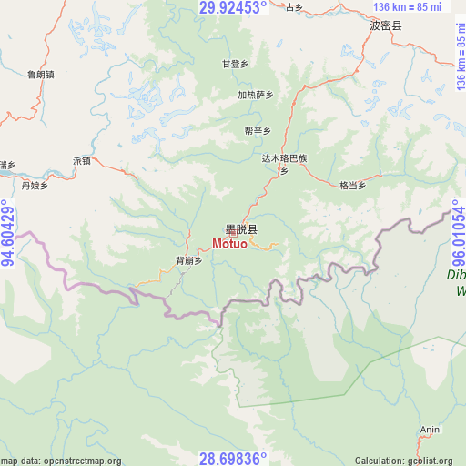
Motuo GPS coordinates[2]
29° 18' 47.844" North, 95° 18' 26.676" East
| Map corner | latitude | longitude |
|---|---|---|
| Upper-left | 29.92453°, | 94.60429° |
| Center: | 29.31329°, | 95.30741° |
| Lower-right: | 28.69836°, | 96.01054° |
| Map W x H: | 136.3×136.3 km | = 84.7×84.7mi |
| max Lat: | 53.31946° ⇑61.8% North |
| Motuo: | 29.31329° |
| min Lat: | ⇓38.2% South 18.22056° |
| min Long | Motuo | max Long |
| 75.07348° | 95.30741° | 134.28917° |
| W 4%⇐ | ⇒96% E |
Elevation
Elevation of Motuo is 977 m = 3205 ft, and this is 492.2 m = 1615 ft above average elevation for this country.
| Max E: |
5622 m = 18445 ft | 15.1% |
| Motuo | 977 m 3205 ft | |
| Avg. | 484.8 m = 1591 ft | |
Min E: |
-3 m = -10 ft | 84.9% |
See also: China elevation on elevation.city.
Geographical zone
Motuo is located in North temperate zone (between Tropic of Cancer and the Arctic Circle). Distance of this Northern Tropic circle is 653.4 km =406 mi to South.| Distance of | km | miles | from Motuo |
|---|---|---|---|
| North Pole | 6747.7 | 4192.8 | to North |
| Arctic Circle | 4141.8 | 2573.6 | to North |
| Tropic Cancer | 653.4 | 406 | to South |
| Equator | 3259.3 | 2025.2 | to South |


Nearby cities:
15 places around Motuo: (largest is in red/bold)
• Baiba
150.7 km =93.6 mi,  291°
291°
• Bayi
99.5 km =61.8 mi, 292°
• Damnyain
60.2 km =37.4 mi,  284°
284°
• Gengzhang
126.3 km =78.5 mi, 291°
• Lunang
73.1 km =45.4 mi,  309°
309°
• Mainling
106.7 km =66.3 mi,  264°
264°
• Mainri
70.5 km =43.8 mi, 286°
• Nailung
141.4 km =87.9 mi, 260°
• Nanyi
109.4 km =68 mi, 262°
• Paicun
49.5 km =30.8 mi,  295°
295°
• Puqu
88 km =54.7 mi, 281°
• Tungdor
119.4 km =74.2 mi, 263°
• Yinla
85.1 km =52.9 mi, 290°
• Zhamog
75.4 km =46.9 mi,  35°
35°
• Zhaxirabdain
120.9 km =75.1 mi,  265°
265°
Sources, notices
• [Note1] Compared only with cities in China existing in our database
• [Src1] Map data: © OpenStreetMap contributors (CC-BY-SA)
• [Src2] Other city data from geonames.org with taken over terms of usage.
• [Src3] Geographical zone / Annual Mean Temperature by Robert A. Rohde @ Wikipedia
