Zhamog geodata
Zhamog (Tibet) is a seat of a third-order administrative division; located in China in Asia/Shanghai (GMT+8) time zone. In our database, there are 1268 cities with bigger population. Compared to other cities in China, 55.5% of cities are located further ↑North; 95.9% of cities are located further →East and 96.3% of cities have lower elevation than Zhamog. Note1


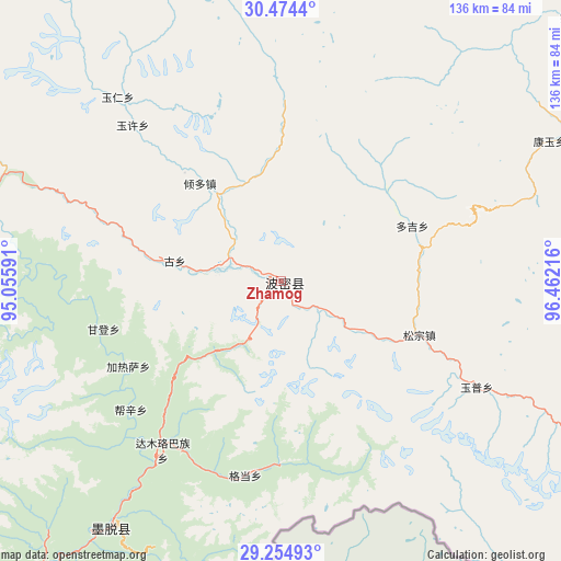
Zhamog GPS coordinates[2]
29° 51' 59.508" North, 95° 45' 32.508" East
| Map corner | latitude | longitude |
|---|---|---|
| Upper-left | 30.4744°, | 95.05591° |
| Center: | 29.86653°, | 95.75903° |
| Lower-right: | 29.25493°, | 96.46216° |
| Map W x H: | 135.6×135.6 km | = 84.3×84.3mi |
| max Lat: | 53.31946° ⇑55.5% North |
| Zhamog: | 29.86653° |
| min Lat: | ⇓44.5% South 18.22056° |
| min Long | Zhamog | max Long |
| 75.07348° | 95.75903° | 134.28917° |
| W 4.1%⇐ | ⇒95.9% E |
Elevation
Elevation of Zhamog is 2736 m = 8976 ft, and this is 2251.2 m = 7386 ft above average elevation for this country.
| Max E: |
5622 m = 18445 ft | 3.7% |
| Zhamog | 2736 m 8976 ft | |
| Avg. | 484.8 m = 1591 ft | |
Min E: |
-3 m = -10 ft | 96.3% |
See also: China elevation on elevation.city.
Geographical zone
Zhamog is located in North temperate zone (between Tropic of Cancer and the Arctic Circle). Distance of this Northern Tropic circle is 714.9 km =444.2 mi to South.| Distance of | km | miles | from Zhamog |
|---|---|---|---|
| North Pole | 6686.2 | 4154.6 | to North |
| Arctic Circle | 4080.3 | 2535.4 | to North |
| Tropic Cancer | 714.9 | 444.2 | to South |
| Equator | 3320.8 | 2063.4 | to South |


Nearby cities:
15 places around Zhamog: (largest is in red/bold)
• Baima
113.7 km =70.6 mi,  79°
79°
• Banbar
139.1 km =86.4 mi,  320°
320°
• Bayi
137.1 km =85.2 mi,  260°
260°
• Coka
155.8 km =96.8 mi, 317°
• Damnyain
112.1 km =69.7 mi,  245°
245°
• Lunang
100.8 km =62.6 mi, 261°
• Mainri
118.2 km =73.4 mi, 249°
• Mawu
128.4 km =79.8 mi,  334°
334°
• Motuo
75.4 km =46.9 mi,  215°
215°
• Paicun
96.6 km =60 mi, 245°
• Puqu
136.9 km =85.1 mi, 251°
• Reyu
155.8 km =96.8 mi,  337°
337°
• Towa
150.1 km =93.3 mi, 327°
• Yinla
127.3 km =79.1 mi, 255°
• Zito
97.3 km =60.5 mi,  4°
4°
Sources, notices
• [Note1] Compared only with cities in China existing in our database
• [Src1] Map data: © OpenStreetMap contributors (CC-BY-SA)
• [Src2] Other city data from geonames.org with taken over terms of usage.
• [Src3] Geographical zone / Annual Mean Temperature by Robert A. Rohde @ Wikipedia
