Gyamotang geodata
Gyamotang (Tibet) is a seat of a third-order administrative division; located in China in Asia/Shanghai (GMT+8) time zone. In our database, there are 1268 cities with bigger population. Compared to other cities in China, 58.6% of cities are located further ↓South; 96% of cities are located further →East and 100% of cities have lower elevation than Gyamotang. Note1


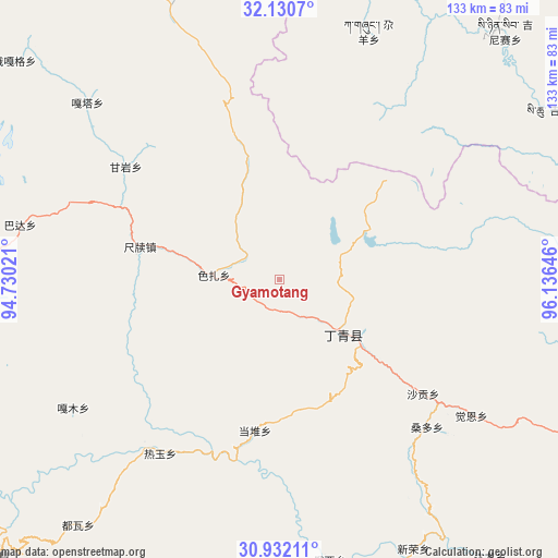
Gyamotang GPS coordinates[2]
31° 31' 59.988" North, 95° 25' 59.988" East
| Map corner | latitude | longitude |
|---|---|---|
| Upper-left | 32.1307°, | 94.73021° |
| Center: | 31.53333°, | 95.43333° |
| Lower-right: | 30.93211°, | 96.13646° |
| Map W x H: | 133.3×133.3 km | = 82.8×82.8mi |
| max Lat: | 53.31946° ⇑41.4% North |
| Gyamotang: | 31.53333° |
| min Lat: | ⇓58.6% South 18.22056° |
| min Long | Gyamotang | max Long |
| 75.07348° | 95.43333° | 134.28917° |
| W 4%⇐ | ⇒96% E |
Elevation
Elevation of Gyamotang is 4955 m = 16257 ft, and this is 4470.2 m = 14666 ft above average elevation for this country.
| Max E: |
5622 m = 18445 ft | 0% |
| Gyamotang | 4955 m 16257 ft | |
| Avg. | 484.8 m = 1591 ft | |
Min E: |
-3 m = -10 ft | 100% |
See also: China elevation on elevation.city.
Geographical zone
Gyamotang is located in North temperate zone (between Tropic of Cancer and the Arctic Circle). Distance of this Northern Tropic circle is 900.3 km =559.4 mi to South.| Distance of | km | miles | from Gyamotang |
|---|---|---|---|
| North Pole | 6500.9 | 4039.5 | to North |
| Arctic Circle | 3895 | 2420.2 | to North |
| Tropic Cancer | 900.3 | 559.4 | to South |
| Equator | 3506.2 | 2178.7 | to South |


Nearby cities:
15 places around Gyamotang: (largest is in red/bold)
• Dingqing
19.7 km =12.2 mi,  133°
133°
• Domba
87.7 km =54.5 mi,  9°
9°
• Garmo
57.7 km =35.9 mi,  238°
238°
• Gaxung
63 km =39.1 mi,  19°
19°
• Jinisai
80 km =49.7 mi,  42°
42°
• Jiqu
79.5 km =49.4 mi,  54°
54°
• Marxog
95.6 km =59.4 mi,  230°
230°
• Mawu
72.8 km =45.2 mi,  198°
198°
• Reyu
50.4 km =31.3 mi,  214°
214°
• Rongbo
75.9 km =47.2 mi,  271°
271°
• Sechang
73.6 km =45.7 mi, 265°
• Shading
94.1 km =58.5 mi,  251°
251°
• Towa
76.1 km =47.3 mi,  219°
219°
• Xiexiong
22.4 km =13.9 mi, 127°
• Zito
96.3 km =59.8 mi,  156°
156°
Sources, notices
• [Note1] Compared only with cities in China existing in our database
• [Src1] Map data: © OpenStreetMap contributors (CC-BY-SA)
• [Src2] Other city data from geonames.org with taken over terms of usage.
• [Src3] Geographical zone / Annual Mean Temperature by Robert A. Rohde @ Wikipedia
