Besterek geodata
Besterek (Xinjiang) is a seat of a fourth-order administrative division; located in China in Asia/Urumqi (GMT+6) time zone. In our database, there are 1268 cities with bigger population. Compared to other cities in China, 97.6% of cities are located further ↓South; 98.4% of cities are located further →East and 88.6% of cities have lower elevation than Besterek. Note1


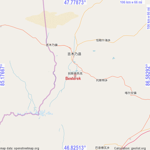
Besterek GPS coordinates[2]
47° 18' 14.688" North, 85° 52' 47.244" East
| Map corner | latitude | longitude |
|---|---|---|
| Upper-left | 47.77873°, | 85.17667° |
| Center: | 47.30408°, | 85.87979° |
| Lower-right: | 46.82513°, | 86.58292° |
| Map W x H: | 106×106 km | = 65.9×65.9mi |
| max Lat: | 53.31946° ⇑2.4% North |
| Besterek: | 47.30408° |
| min Lat: | ⇓97.6% South 18.22056° |
| min Long | Besterek | max Long |
| 75.07348° | 85.87979° | 134.28917° |
| W 1.6%⇐ | ⇒98.4% E |
Elevation
Elevation of Besterek is 1234 m = 4049 ft, and this is 749.2 m = 2458 ft above average elevation for this country.
| Max E: |
5622 m = 18445 ft | 11.4% |
| Besterek | 1234 m 4049 ft | |
| Avg. | 484.8 m = 1591 ft | |
Min E: |
-3 m = -10 ft | 88.6% |
See also: China elevation on elevation.city.
Geographical zone
Besterek is located in North temperate zone (between Tropic of Cancer and the Arctic Circle). Distance of this North polar circle is 2141.5 km =1330.7 mi to North.| Distance of | km | miles | from Besterek |
|---|---|---|---|
| North Pole | 4747.3 | 2949.8 | to North |
| Arctic Circle | 2141.5 | 1330.7 | to North |
| Tropic Cancer | 2653.8 | 1649 | to South |
| Equator | 5259.7 | 3268.2 | to South |


Nearby cities:
15 places around Besterek: (largest is in red/bold)
• Bayinaobao
54.6 km =33.9 mi,  159°
159°
• Egiztobe
104.5 km =64.9 mi,  53°
53°
• Hoboksar
57.8 km =35.9 mi,  191°
191°
• Hoxtolgay
87.8 km =54.6 mi,  173°
173°
• Jeminay
29.3 km =18.2 mi,  317°
317°
• Jetaral
120.5 km =74.9 mi,  100°
100°
• Karjaw
41.1 km =25.5 mi,  107°
107°
• Motge
55 km =34.2 mi, 186°
• Oymak
104.9 km =65.2 mi, 52°
• Qagan Hol
54.5 km =33.9 mi, 173°
• Tiebukenwusan
64.4 km =40 mi,  210°
210°
• Topterek
14.5 km =9 mi,  357°
357°
• Tost
19 km =11.8 mi, 100°
• Xalxikay
35.1 km =21.8 mi, 46°
• Xazgat
110.2 km =68.5 mi, 165°
Sources, notices
• [Note1] Compared only with cities in China existing in our database
• [Src1] Map data: © OpenStreetMap contributors (CC-BY-SA)
• [Src2] Other city data from geonames.org with taken over terms of usage.
• [Src3] Geographical zone / Annual Mean Temperature by Robert A. Rohde @ Wikipedia
