Xazgat geodata
Xazgat (Xinjiang) is a seat of a fourth-order administrative division; located in China in Asia/Urumqi (GMT+6) time zone. In our database, there are 1268 cities with bigger population. Compared to other cities in China, 95.6% of cities are located further ↓South; 98.3% of cities are located further →East and 76.8% of cities have lower elevation than Xazgat. Note1


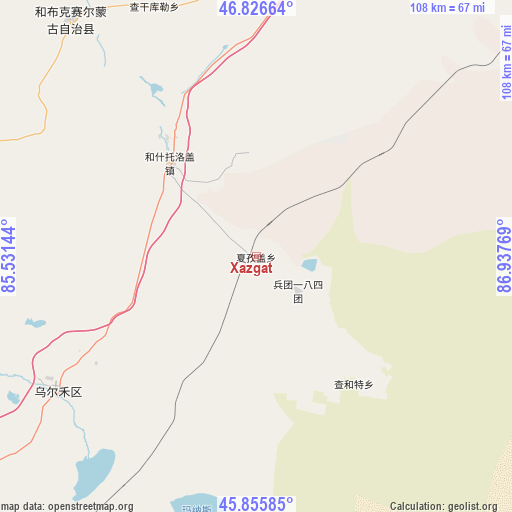
Xazgat GPS coordinates[2]
46° 20' 36.24" North, 86° 14' 4.416" East
| Map corner | latitude | longitude |
|---|---|---|
| Upper-left | 46.82664°, | 85.53144° |
| Center: | 46.3434°, | 86.23456° |
| Lower-right: | 45.85585°, | 86.93769° |
| Map W x H: | 107.9×107.9 km | = 67×67mi |
| max Lat: | 53.31946° ⇑4.4% North |
| Xazgat: | 46.3434° |
| min Lat: | ⇓95.6% South 18.22056° |
| min Long | Xazgat | max Long |
| 75.07348° | 86.23456° | 134.28917° |
| W 1.7%⇐ | ⇒98.3% E |
Elevation
Elevation of Xazgat is 572 m = 1877 ft, and this is 87.2 m = 286 ft above average elevation for this country.
| Max E: |
5622 m = 18445 ft | 23.2% |
| Xazgat | 572 m 1877 ft | |
| Avg. | 484.8 m = 1591 ft | |
Min E: |
-3 m = -10 ft | 76.8% |
See also: China elevation on elevation.city.
Geographical zone
Xazgat is located in North temperate zone (between Tropic of Cancer and the Arctic Circle). Distance of this North polar circle is 2248.3 km =1397 mi to North.| Distance of | km | miles | from Xazgat |
|---|---|---|---|
| North Pole | 4854.2 | 3016.3 | to North |
| Arctic Circle | 2248.3 | 1397 | to North |
| Tropic Cancer | 2547 | 1582.6 | to South |
| Equator | 5152.9 | 3201.9 | to South |


Nearby cities:
15 places around Xazgat: (largest is in red/bold)
• Baijiantan
111.3 km =69.2 mi,  229°
229°
• Baikouquan
75.3 km =46.8 mi, 231°
• Bayinaobao
56.2 km =34.9 mi,  352°
352°
• Besterek
110.2 km =68.5 mi, 345°
• Haramgai
122.9 km =76.4 mi,  73°
73°
• Hoboksar
63.5 km =39.5 mi,  322°
322°
• Hoxtolgay
26.4 km =16.4 mi, 317°
• Karjaw
95.1 km =59.1 mi,  7°
7°
• Motge
62 km =38.5 mi,  327°
327°
• Qagan Hol
56.8 km =35.3 mi,  337°
337°
• Sanping
121.5 km =75.5 mi, 228°
• Tiebukenwusan
78.7 km =48.9 mi,  310°
310°
• Topterek
124.4 km =77.3 mi, 347°
• Tost
103.8 km =64.5 mi,  355°
355°
• Urho
49.7 km =30.9 mi,  239°
239°
Sources, notices
• [Note1] Compared only with cities in China existing in our database
• [Src1] Map data: © OpenStreetMap contributors (CC-BY-SA)
• [Src2] Other city data from geonames.org with taken over terms of usage.
• [Src3] Geographical zone / Annual Mean Temperature by Robert A. Rohde @ Wikipedia
