Ubalá geodata
Ubalá (Cundinamarca) is a populated place; located in Colombia in America/Bogota (GMT-5) time zone. With population of 1,886 people, there are 816 cities with bigger population in this country. Compared to other cities in Colombia, 67.3% of cities are located further ↑North; 95.1% of cities are located further ←West and 74.9% of cities have higher elevation than Ubalá. Note1


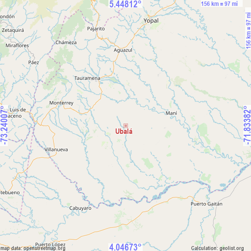
Ubalá GPS coordinates[2]
4° 44' 52.008" North, 72° 32' 12.984" West
| Map corner | latitude | longitude |
|---|---|---|
| Upper-left | 5.44812°, | -73.24007° |
| Center: | 4.74778°, | -72.53694° |
| Lower-right: | 4.04673°, | -71.83382° |
| Map W x H: | 155.8×155.8 km | = 96.8×96.8mi |
| max Lat: | 13.38166° ⇑67.3% North |
| Ubalá: | 4.74778° |
| min Lat: | ⇓32.7% South -4.21528° |
| min Long | Ubalá | max Long |
| -81.70636° | -72.53694° | -67.06996° |
| W 95.1%⇐ | ⇒4.9% E |
Elevation
Elevation of Ubalá is 188 m = 617 ft, and this is 961.3 m = 3154 ft below average elevation for this country.
| Max E: |
3342 m = 10965 ft | 74.9% |
| Avg. | 1149.3 m = 3771 ft | |
| Ubalá | 188 m = 617 ft | |
Min E: |
1 m = 3 ft | 25.1% |
See also: Colombia elevation on elevation.city.
Geographical zone
Ubalá is located in North Torrid zone (between Equator and Tropic of Cancer). Distance of Equator is 527.9 km =328 mi to South.| Distance of | km | miles | from Ubalá |
|---|---|---|---|
| North Pole | 9479.2 | 5890.1 | to North |
| Arctic Circle | 6873.3 | 4270.9 | to North |
| Tropic Cancer | 2078 | 1291.2 | to North |
| Equator | 527.9 | 328 | to South |


Nearby cities:
15 places around Ubalá: (largest is in red/bold)
• Aguazul
47.3 km =29.4 mi,  358°
358°
• Barranca de Upía
51.6 km =32.1 mi,  247°
247°
• Cabuyaro
59.1 km =36.7 mi,  208°
208°
• Chámeza
63.6 km =39.5 mi,  324°
324°
• Maní
29.5 km =18.3 mi,  75°
75°
• Monterrey
42.3 km =26.3 mi,  290°
290°
• Pajarito
63.3 km =39.3 mi,  343°
343°
• Puerto Gaitán
69.9 km =43.4 mi,  133°
133°
• Páez
69.2 km =43 mi,  304°
304°
• Recetor
59 km =36.7 mi, 335°
• Sabanalarga
57 km =35.4 mi,  281°
281°
• Tauramena
38 km =23.6 mi, 322°
• Tibacuy
45 km =28 mi,  168°
168°
• Villanueva
45.8 km =28.5 mi, 250°
• Yopal
67.4 km =41.9 mi,  13°
13°
Sources, notices
• [Note1] Compared only with cities in Colombia existing in our database
• [Src1] Map data: © OpenStreetMap contributors (CC-BY-SA)
• [Src2] Other city data from geonames.org with taken over terms of usage.
• [Src3] Geographical zone / Annual Mean Temperature by Robert A. Rohde @ Wikipedia
