Maní geodata
Maní (Casanare) is a seat of a second-order administrative division; located in Colombia in America/Bogota (GMT-5) time zone. With population of 7,031 people, there are 406 cities with bigger population in this country. Compared to other cities in Colombia, 66.2% of cities are located further ↑North; 97.1% of cities are located further ←West and 76.6% of cities have higher elevation than Maní. Note1


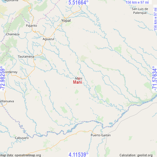
Maní GPS coordinates[2]
4° 48' 58.968" North, 72° 16' 46.056" West
| Map corner | latitude | longitude |
|---|---|---|
| Upper-left | 5.51664°, | -72.98259° |
| Center: | 4.81638°, | -72.27946° |
| Lower-right: | 4.11539°, | -71.57634° |
| Map W x H: | 155.8×155.8 km | = 96.8×96.8mi |
| max Lat: | 13.38166° ⇑66.2% North |
| Maní: | 4.81638° |
| min Lat: | ⇓33.8% South -4.21528° |
| min Long | Maní | max Long |
| -81.70636° | -72.27946° | -67.06996° |
| W 97.1%⇐ | ⇒2.9% E |
Elevation
Elevation of Maní is 164 m = 538 ft, and this is 985.3 m = 3233 ft below average elevation for this country.
| Max E: |
3342 m = 10965 ft | 76.6% |
| Avg. | 1149.3 m = 3771 ft | |
| Maní | 164 m = 538 ft | |
Min E: |
1 m = 3 ft | 23.4% |
See also: Colombia elevation on elevation.city.
Geographical zone
Maní is located in North Torrid zone (between Equator and Tropic of Cancer). Distance of Equator is 535.5 km =332.7 mi to South.| Distance of | km | miles | from Maní |
|---|---|---|---|
| North Pole | 9471.5 | 5885.3 | to North |
| Arctic Circle | 6865.6 | 4266.1 | to North |
| Tropic Cancer | 2070.4 | 1286.5 | to North |
| Equator | 535.5 | 332.7 | to South |


Nearby cities:
15 places around Maní: (largest is in red/bold)
• Aguazul
49.5 km =30.8 mi,  323°
323°
• Barranca de Upía
81 km =50.3 mi,  250°
250°
• Cabuyaro
82.4 km =51.2 mi,  223°
223°
• Chámeza
78.9 km =49 mi,  304°
304°
• Monterrey
68.6 km =42.6 mi,  275°
275°
• Pajarito
70.7 km =43.9 mi, 318°
• Puerto Gaitán
60.1 km =37.3 mi,  158°
158°
• Recetor
70.4 km =43.7 mi,  310°
310°
• Sabanalarga
84.4 km =52.4 mi,  272°
272°
• Tauramena
56.4 km =35 mi,  293°
293°
• Tibacuy
55.3 km =34.4 mi,  200°
200°
• Ubalá
29.5 km =18.3 mi,  255°
255°
• Villanueva
62.4 km =38.8 mi,  33°
33°
• Villanueva
75.3 km =46.8 mi, 252°
• Yopal
59.4 km =36.9 mi,  347°
347°
Sources, notices
• [Note1] Compared only with cities in Colombia existing in our database
• [Src1] Map data: © OpenStreetMap contributors (CC-BY-SA)
• [Src2] Other city data from geonames.org with taken over terms of usage.
• [Src3] Geographical zone / Annual Mean Temperature by Robert A. Rohde @ Wikipedia
