Cabuyaro geodata
Cabuyaro (Meta) is a seat of a second-order administrative division; located in Colombia in America/Bogota (GMT-5) time zone. With population of 1,140 people, there are 924 cities with bigger population in this country. Compared to other cities in Colombia, 75% of cities are located further ↑North; 90.9% of cities are located further ←West and 76.4% of cities have higher elevation than Cabuyaro. Note1


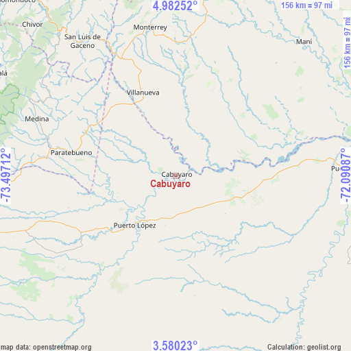
Cabuyaro GPS coordinates[2]
4° 16' 54.12" North, 72° 47' 38.364" West
| Map corner | latitude | longitude |
|---|---|---|
| Upper-left | 4.98252°, | -73.49712° |
| Center: | 4.2817°, | -72.79399° |
| Lower-right: | 3.58023°, | -72.09087° |
| Map W x H: | 155.9×155.9 km | = 96.9×96.9mi |
| max Lat: | 13.38166° ⇑75% North |
| Cabuyaro: | 4.2817° |
| min Lat: | ⇓25% South -4.21528° |
| min Long | Cabuyaro | max Long |
| -81.70636° | -72.79399° | -67.06996° |
| W 90.9%⇐ | ⇒9.1% E |
Elevation
Elevation of Cabuyaro is 165 m = 541 ft, and this is 984.3 m = 3229 ft below average elevation for this country.
| Max E: |
3342 m = 10965 ft | 76.4% |
| Avg. | 1149.3 m = 3771 ft | |
| Cabuyaro | 165 m = 541 ft | |
Min E: |
1 m = 3 ft | 23.6% |
See also: Colombia elevation on elevation.city.
Geographical zone
Cabuyaro is located in North Torrid zone (between Equator and Tropic of Cancer). Distance of Equator is 476.1 km =295.8 mi to South.| Distance of | km | miles | from Cabuyaro |
|---|---|---|---|
| North Pole | 9531 | 5922.3 | to North |
| Arctic Circle | 6925.1 | 4303.1 | to North |
| Tropic Cancer | 2129.8 | 1323.4 | to North |
| Equator | 476.1 | 295.8 | to South |


Nearby cities:
15 places around Cabuyaro: (largest is in red/bold)
• Barranca de Upía
37.3 km =23.2 mi,  329°
329°
• Cumaral
76.8 km =47.7 mi,  269°
269°
• Maní
82.4 km =51.2 mi,  43°
43°
• Medina
66.6 km =41.4 mi,  292°
292°
• Monterrey
67.3 km =41.8 mi,  350°
350°
• Paratebueno
47.9 km =29.8 mi,  282°
282°
• Puerto Gaitán
79.1 km =49.2 mi,  87°
87°
• Puerto López
27.1 km =16.8 mi,  221°
221°
• Sabanalarga
69.3 km =43.1 mi,  336°
336°
• San Carlos de Guaroa
80.6 km =50.1 mi, 218°
• San Luis de Gaceno
72.9 km =45.3 mi, 325°
• Tauramena
82 km =51 mi,  3°
3°
• Tibacuy
38.2 km =23.7 mi,  78°
78°
• Ubalá
59.1 km =36.7 mi,  28°
28°
• Villanueva
39.6 km =24.6 mi, 338°
Sources, notices
• [Note1] Compared only with cities in Colombia existing in our database
• [Src1] Map data: © OpenStreetMap contributors (CC-BY-SA)
• [Src2] Other city data from geonames.org with taken over terms of usage.
• [Src3] Geographical zone / Annual Mean Temperature by Robert A. Rohde @ Wikipedia
