Arcabuco geodata
Arcabuco (Boyacá) is a seat of a second-order administrative division; located in Colombia in America/Bogota (GMT-5) time zone. With population of 1,564 people, there are 858 cities with bigger population in this country. Compared to other cities in Colombia, 55.1% of cities are located further ↓South; 77.2% of cities are located further ←West and 91.4% of cities have lower elevation than Arcabuco. Note1


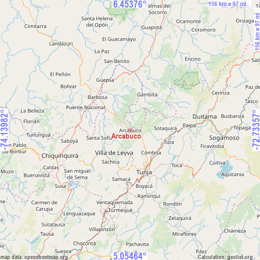
Arcabuco GPS coordinates[2]
5° 45' 16.668" North, 73° 26' 12.084" West
| Map corner | latitude | longitude |
|---|---|---|
| Upper-left | 6.45376°, | -74.13982° |
| Center: | 5.75463°, | -73.43669° |
| Lower-right: | 5.05464°, | -72.73357° |
| Map W x H: | 155.6×155.6 km | = 96.7×96.7mi |
| max Lat: | 13.38166° ⇑44.9% North |
| Arcabuco: | 5.75463° |
| min Lat: | ⇓55.1% South -4.21528° |
| min Long | Arcabuco | max Long |
| -81.70636° | -73.43669° | -67.06996° |
| W 77.2%⇐ | ⇒22.8% E |
Elevation
Elevation of Arcabuco is 2566 m = 8419 ft, and this is 1416.7 m = 4648 ft above average elevation for this country.
| Max E: |
3342 m = 10965 ft | 8.6% |
| Arcabuco | 2566 m 8419 ft | |
| Avg. | 1149.3 m = 3771 ft | |
Min E: |
1 m = 3 ft | 91.4% |
See also: Colombia elevation on elevation.city.
Geographical zone
Arcabuco is located in North Torrid zone (between Equator and Tropic of Cancer). Distance of Equator is 639.9 km =397.6 mi to South.| Distance of | km | miles | from Arcabuco |
|---|---|---|---|
| North Pole | 9367.2 | 5820.5 | to North |
| Arctic Circle | 6761.3 | 4201.3 | to North |
| Tropic Cancer | 1966.1 | 1221.7 | to North |
| Equator | 639.9 | 397.6 | to South |


Nearby cities:
15 places around Arcabuco: (largest is in red/bold)
• Chíquiza
17.6 km =10.9 mi,  197°
197°
• Combita
18.9 km =11.7 mi,  135°
135°
• Cucaita
23.5 km =14.6 mi,  184°
184°
• Cómbita
18.4 km =11.4 mi, 137°
• Gachantivá
11.4 km =7.1 mi,  271°
271°
• La Capilla
7 km =4.3 mi,  217°
217°
• Moniquirá
20.3 km =12.6 mi,  311°
311°
• Motavita
21.3 km =13.2 mi,  158°
158°
• Oicatá
22.7 km =14.1 mi, 141°
• Santa Sofía
19.2 km =11.9 mi,  254°
254°
• Sora
21.1 km =13.1 mi, 184°
• Sotaquirá
21 km =13 mi,  86°
86°
• Sáchica
22.2 km =13.8 mi,  211°
211°
• Togüí
21.7 km =13.5 mi,  337°
337°
• Villa de Leyva
16.5 km =10.3 mi, 215°
Sources, notices
• [Note1] Compared only with cities in Colombia existing in our database
• [Src1] Map data: © OpenStreetMap contributors (CC-BY-SA)
• [Src2] Other city data from geonames.org with taken over terms of usage.
• [Src3] Geographical zone / Annual Mean Temperature by Robert A. Rohde @ Wikipedia
