La Capilla geodata
La Capilla (Boyacá) is a populated place; located in Colombia in America/Bogota (GMT-5) time zone. With population of 1,375 people, there are 888 cities with bigger population in this country. Compared to other cities in Colombia, 53.9% of cities are located further ↓South; 76.2% of cities are located further ←West and 91.6% of cities have lower elevation than La Capilla. Note1


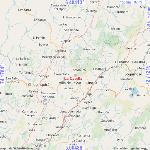
La Capilla GPS coordinates[2]
5° 42' 17.748" North, 73° 28' 30.972" West
| Map corner | latitude | longitude |
|---|---|---|
| Upper-left | 6.40413°, | -74.1784° |
| Center: | 5.70493°, | -73.47527° |
| Lower-right: | 5.00488°, | -72.77215° |
| Map W x H: | 155.6×155.6 km | = 96.7×96.7mi |
| max Lat: | 13.38166° ⇑46.1% North |
| La Capilla: | 5.70493° |
| min Lat: | ⇓53.9% South -4.21528° |
| min Long | La Capilla | max Long |
| -81.70636° | -73.47527° | -67.06996° |
| W 76.2%⇐ | ⇒23.8% E |
Elevation
Elevation of La Capilla is 2576 m = 8451 ft, and this is 1426.7 m = 4681 ft above average elevation for this country.
| Max E: |
3342 m = 10965 ft | 8.4% |
| La Capilla | 2576 m 8451 ft | |
| Avg. | 1149.3 m = 3771 ft | |
Min E: |
1 m = 3 ft | 91.6% |
See also: Colombia elevation on elevation.city.
Geographical zone
La Capilla is located in North Torrid zone (between Equator and Tropic of Cancer). Distance of Equator is 634.3 km =394.1 mi to South.| Distance of | km | miles | from La Capilla |
|---|---|---|---|
| North Pole | 9372.7 | 5823.9 | to North |
| Arctic Circle | 6766.8 | 4204.7 | to North |
| Tropic Cancer | 1971.6 | 1225.1 | to North |
| Equator | 634.3 | 394.1 | to South |


Nearby cities:
15 places around La Capilla: (largest is in red/bold)
• Arcabuco
7 km =4.3 mi,  37°
37°
• Chíquiza
11.3 km =7 mi,  185°
185°
• Combita
19.3 km =12 mi,  114°
114°
• Cucaita
18.1 km =11.2 mi,  172°
172°
• Cómbita
18.5 km =11.5 mi,  115°
115°
• Gachantivá
9.1 km =5.7 mi,  308°
308°
• Moniquirá
21.9 km =13.6 mi,  330°
330°
• Motavita
18.6 km =11.6 mi,  139°
139°
• Oicatá
22.1 km =13.7 mi, 123°
• Santa Sofía
14.3 km =8.9 mi,  271°
271°
• Sora
15.8 km =9.8 mi, 169°
• Sutamarchán
18.6 km =11.6 mi,  237°
237°
• Sáchica
15.3 km =9.5 mi,  208°
208°
• Tunja
22.3 km =13.9 mi,  147°
147°
• Villa de Leyva
9.6 km =6 mi, 214°
Sources, notices
• [Note1] Compared only with cities in Colombia existing in our database
• [Src1] Map data: © OpenStreetMap contributors (CC-BY-SA)
• [Src2] Other city data from geonames.org with taken over terms of usage.
• [Src3] Geographical zone / Annual Mean Temperature by Robert A. Rohde @ Wikipedia
