Bogotá geodata
Bogotá (Bogota D.C.) is a capital of a political entity; located in Colombia in America/Bogota (GMT-5) time zone. With population of 7,674,366 people, there are 0 cities with bigger population in this country. Compared to other cities in Colombia, 69.7% of cities are located further ↑North; 63.3% of cities are located further ←West and 92.2% of cities have lower elevation than Bogotá. Note1


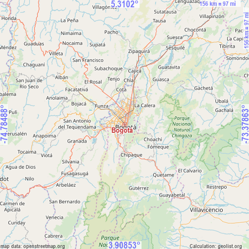
Bogotá GPS coordinates[2]
4° 36' 34.956" North, 74° 4' 54.3" West
| Map corner | latitude | longitude |
|---|---|---|
| Upper-left | 5.3102°, | -74.78488° |
| Center: | 4.60971°, | -74.08175° |
| Lower-right: | 3.90853°, | -73.37863° |
| Map W x H: | 155.9×155.9 km | = 96.9×96.9mi |
| max Lat: | 13.38166° ⇑69.7% North |
| Bogotá: | 4.60971° |
| min Lat: | ⇓30.3% South -4.21528° |
| min Long | Bogotá | max Long |
| -81.70636° | -74.08175° | -67.06996° |
| W 63.3%⇐ | ⇒36.7% E |
Elevation
Elevation of Bogotá is 2582 m = 8471 ft, and this is 1432.7 m = 4700 ft above average elevation for this country.
| Max E: |
3342 m = 10965 ft | 7.8% |
| Bogotá | 2582 m 8471 ft | |
| Avg. | 1149.3 m = 3771 ft | |
Min E: |
1 m = 3 ft | 92.2% |
See also: Bogotá elevation on elevation.city.
Geographical zone
Bogotá is located in North Torrid zone (between Equator and Tropic of Cancer). Distance of Equator is 512.6 km =318.5 mi to South.| Distance of | km | miles | from Bogotá |
|---|---|---|---|
| North Pole | 9494.5 | 5899.6 | to North |
| Arctic Circle | 6888.6 | 4280.4 | to North |
| Tropic Cancer | 2093.4 | 1300.8 | to North |
| Equator | 512.6 | 318.5 | to South |


Nearby cities:
15 places around Bogotá: (largest is in red/bold)
• Barrio San Luis
9.3 km =5.8 mi,  45°
45°
• Chipaque
19.1 km =11.9 mi,  167°
167°
• Choachí
19.8 km =12.3 mi,  116°
116°
• Chía
27.8 km =17.3 mi,  5°
5°
• Cota
22.3 km =13.9 mi,  355°
355°
• Cáqueza
27.2 km =16.9 mi,  146°
146°
• Funza
18.7 km =11.6 mi,  309°
309°
• Fómeque
24.5 km =15.2 mi, 123°
• La Calera
17.5 km =10.9 mi, 45°
• Madrid
24.4 km =15.2 mi,  304°
304°
• Mosquera
19.6 km =12.2 mi, 303°
• Sibaté
23.7 km =14.7 mi,  236°
236°
• Soacha
15.3 km =9.5 mi,  257°
257°
• Ubaque
21 km =13 mi,  130°
130°
• Une
23.8 km =14.8 mi,  164°
164°
In other languages:
- In Spanish: Bogotá, Santafé de Bogotá, Santafe de Bogotá
- In France: Bogota
- In Russian: Богота
- In Chinese: 波哥大
Sources, notices
• [Note1] Compared only with cities in Colombia existing in our database
• [Src1] Map data: © OpenStreetMap contributors (CC-BY-SA)
• [Src2] Other city data from geonames.org with taken over terms of usage.
• [Src3] Geographical zone / Annual Mean Temperature by Robert A. Rohde @ Wikipedia
