Saravena geodata
Saravena (Arauca) is a seat of a second-order administrative division; located in Colombia in America/Bogota (GMT-5) time zone. In our database, there are 1053 cities with bigger population. Compared to other cities in Colombia, 73.7% of cities are located further ↓South; 98.2% of cities are located further ←West and 73.3% of cities have higher elevation than Saravena. Note1


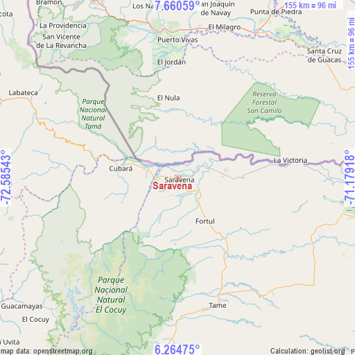
Saravena GPS coordinates[2]
6° 57' 47.484" North, 71° 52' 56.28" West
| Map corner | latitude | longitude |
|---|---|---|
| Upper-left | 7.66059°, | -72.58543° |
| Center: | 6.96319°, | -71.8823° |
| Lower-right: | 6.26475°, | -71.17918° |
| Map W x H: | 155.2×155.2 km | = 96.4×96.4mi |
| max Lat: | 13.38166° ⇑26.3% North |
| Saravena: | 6.96319° |
| min Lat: | ⇓73.7% South -4.21528° |
| min Long | Saravena | max Long |
| -81.70636° | -71.8823° | -67.06996° |
| W 98.2%⇐ | ⇒1.8% E |
Elevation
Elevation of Saravena is 225 m = 738 ft, and this is 924.3 m = 3032 ft below average elevation for this country.
| Max E: |
3342 m = 10965 ft | 73.3% |
| Avg. | 1149.3 m = 3771 ft | |
| Saravena | 225 m = 738 ft | |
Min E: |
1 m = 3 ft | 26.7% |
See also: Colombia elevation on elevation.city.
Geographical zone
Saravena is located in North Torrid zone (between Equator and Tropic of Cancer). Distance of Equator is 774.2 km =481.1 mi to South.| Distance of | km | miles | from Saravena |
|---|---|---|---|
| North Pole | 9232.8 | 5737 | to North |
| Arctic Circle | 6626.9 | 4117.8 | to North |
| Tropic Cancer | 1831.7 | 1138.2 | to North |
| Equator | 774.2 | 481.1 | to South |


Nearby cities:
15 places around Saravena: (largest is in red/bold)
• Arauquita
50.7 km =31.5 mi,  81°
81°
• Carcasí
90.2 km =56 mi,  245°
245°
• Chiscas
82.2 km =51.1 mi,  236°
236°
• Chitagá
88.5 km =55 mi,  282°
282°
• Cubará
25.1 km =15.6 mi, 280°
• El Cocuy
87.6 km =54.4 mi,  225°
225°
• El Espino
86.4 km =53.7 mi, 231°
• Fortul
22.3 km =13.9 mi,  148°
148°
• Guacamayas
88.4 km =54.9 mi, 230°
• Güicán
80.8 km =50.2 mi, 226°
• Herrán
89.7 km =55.7 mi,  312°
312°
• Labateca
77.2 km =48 mi,  298°
298°
• Panqueba
86.2 km =53.6 mi, 228°
• Tame
58.2 km =36.2 mi,  163°
163°
• Toledo
76.7 km =47.7 mi, 300°
Sources, notices
• [Note1] Compared only with cities in Colombia existing in our database
• [Src1] Map data: © OpenStreetMap contributors (CC-BY-SA)
• [Src2] Other city data from geonames.org with taken over terms of usage.
• [Src3] Geographical zone / Annual Mean Temperature by Robert A. Rohde @ Wikipedia
