Tame geodata
Tame (Arauca) is a seat of a second-order administrative division; located in Colombia in America/Bogota (GMT-5) time zone. With population of 29,099 people, there are 125 cities with bigger population in this country. Compared to other cities in Colombia, 67.4% of cities are located further ↓South; 98.5% of cities are located further ←West and 68.9% of cities have higher elevation than Tame. Note1


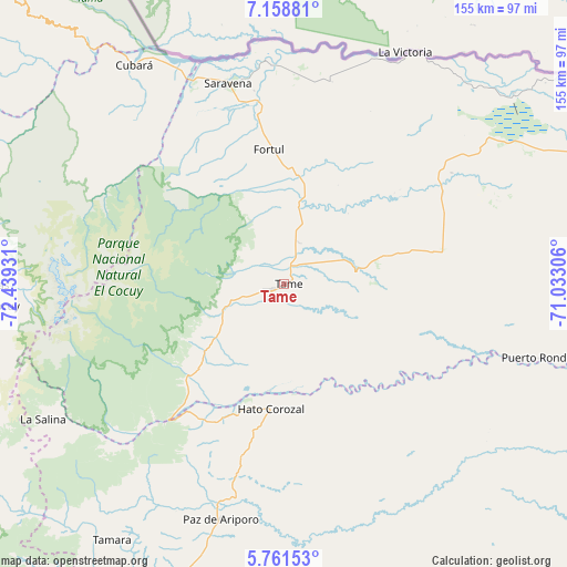
Tame GPS coordinates[2]
6° 27' 38.34" North, 71° 44' 10.248" West
| Map corner | latitude | longitude |
|---|---|---|
| Upper-left | 7.15881°, | -72.43931° |
| Center: | 6.46065°, | -71.73618° |
| Lower-right: | 5.76153°, | -71.03306° |
| Map W x H: | 155.4×155.4 km | = 96.6×96.6mi |
| max Lat: | 13.38166° ⇑32.6% North |
| Tame: | 6.46065° |
| min Lat: | ⇓67.4% South -4.21528° |
| min Long | Tame | max Long |
| -81.70636° | -71.73618° | -67.06996° |
| W 98.5%⇐ | ⇒1.5% E |
Elevation
Elevation of Tame is 320 m = 1050 ft, and this is 829.3 m = 2721 ft below average elevation for this country.
| Max E: |
3342 m = 10965 ft | 68.9% |
| Avg. | 1149.3 m = 3771 ft | |
| Tame | 320 m = 1050 ft | |
Min E: |
1 m = 3 ft | 31.1% |
See also: Colombia elevation on elevation.city.
Geographical zone
Tame is located in North Torrid zone (between Equator and Tropic of Cancer). Distance of Equator is 718.4 km =446.4 mi to South.| Distance of | km | miles | from Tame |
|---|---|---|---|
| North Pole | 9288.7 | 5771.7 | to North |
| Arctic Circle | 6682.8 | 4152.5 | to North |
| Tropic Cancer | 1887.6 | 1172.9 | to North |
| Equator | 718.4 | 446.4 | to South |


Nearby cities:
15 places around Tame: (largest is in red/bold)
• Arauquita
71.8 km =44.6 mi,  28°
28°
• Cubará
73.1 km =45.4 mi,  326°
326°
• El Cocuy
78.9 km =49 mi,  266°
266°
• El Espino
84.1 km =52.3 mi, 271°
• Fortul
37.2 km =23.1 mi,  353°
353°
• Guacamayas
84.9 km =52.8 mi, 270°
• Güicán
75 km =46.6 mi, 270°
• La Salina
75.9 km =47.2 mi,  241°
241°
• Municipio Hato Corozal
33.9 km =21.1 mi,  185°
185°
• Panqueba
80.3 km =49.9 mi, 268°
• Paz de Ariporo
66.7 km =41.4 mi, 194°
• Puerto Rondón
73.1 km =45.4 mi,  105°
105°
• Saravena
58.2 km =36.2 mi,  343°
343°
• Sácama
69.5 km =43.2 mi,  234°
234°
• Támara
84.5 km =52.5 mi,  213°
213°
Sources, notices
• [Note1] Compared only with cities in Colombia existing in our database
• [Src1] Map data: © OpenStreetMap contributors (CC-BY-SA)
• [Src2] Other city data from geonames.org with taken over terms of usage.
• [Src3] Geographical zone / Annual Mean Temperature by Robert A. Rohde @ Wikipedia
