Cubará geodata
Cubará (Boyacá) is a seat of a second-order administrative division; located in Colombia in America/Bogota (GMT-5) time zone. With population of 1,466 people, there are 871 cities with bigger population in this country. Compared to other cities in Colombia, 74.3% of cities are located further ↓South; 97.7% of cities are located further ←West and 67.2% of cities have higher elevation than Cubará. Note1


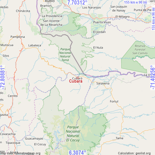
Cubará GPS coordinates[2]
7° 0' 20.808" North, 72° 6' 20.448" West
| Map corner | latitude | longitude |
|---|---|---|
| Upper-left | 7.70312°, | -72.80881° |
| Center: | 7.00578°, | -72.10568° |
| Lower-right: | 6.3074°, | -71.40256° |
| Map W x H: | 155.2×155.2 km | = 96.4×96.4mi |
| max Lat: | 13.38166° ⇑25.7% North |
| Cubará: | 7.00578° |
| min Lat: | ⇓74.3% South -4.21528° |
| min Long | Cubará | max Long |
| -81.70636° | -72.10568° | -67.06996° |
| W 97.7%⇐ | ⇒2.3% E |
Elevation
Elevation of Cubará is 351 m = 1152 ft, and this is 798.3 m = 2619 ft below average elevation for this country.
| Max E: |
3342 m = 10965 ft | 67.2% |
| Avg. | 1149.3 m = 3771 ft | |
| Cubará | 351 m = 1152 ft | |
Min E: |
1 m = 3 ft | 32.8% |
See also: Colombia elevation on elevation.city.
Geographical zone
Cubará is located in North Torrid zone (between Equator and Tropic of Cancer). Distance of Equator is 779 km =484 mi to South.| Distance of | km | miles | from Cubará |
|---|---|---|---|
| North Pole | 9228.1 | 5734.1 | to North |
| Arctic Circle | 6622.2 | 4114.8 | to North |
| Tropic Cancer | 1826.9 | 1135.2 | to North |
| Equator | 779 | 484 | to South |


Nearby cities:
15 places around Cubará: (largest is in red/bold)
• Carcasí
71.2 km =44.2 mi,  233°
233°
• Cerrito
67.4 km =41.9 mi,  254°
254°
• Chiscas
66.5 km =41.3 mi,  221°
221°
• Chitagá
63.4 km =39.4 mi,  283°
283°
• Concepción
70.2 km =43.6 mi, 247°
• Cácota
66 km =41 mi,  296°
296°
• El Espino
72.5 km =45 mi, 216°
• Fortul
43.4 km =27 mi,  123°
123°
• Güicán
69.1 km =42.9 mi,  209°
209°
• Herrán
69.5 km =43.2 mi,  323°
323°
• Labateca
53.9 km =33.5 mi,  307°
307°
• Pamplona
72.6 km =45.1 mi, 304°
• Saravena
25.1 km =15.6 mi,  100°
100°
• Tame
73.1 km =45.4 mi,  146°
146°
• Toledo
53.6 km =33.3 mi, 309°
Sources, notices
• [Note1] Compared only with cities in Colombia existing in our database
• [Src1] Map data: © OpenStreetMap contributors (CC-BY-SA)
• [Src2] Other city data from geonames.org with taken over terms of usage.
• [Src3] Geographical zone / Annual Mean Temperature by Robert A. Rohde @ Wikipedia
