Fortul geodata
Fortul (Arauca) is a seat of a second-order administrative division; located in Colombia in America/Bogota (GMT-5) time zone. With population of 4,607 people, there are 539 cities with bigger population in this country. Compared to other cities in Colombia, 72.5% of cities are located further ↓South; 98.3% of cities are located further ←West and 72.5% of cities have higher elevation than Fortul. Note1


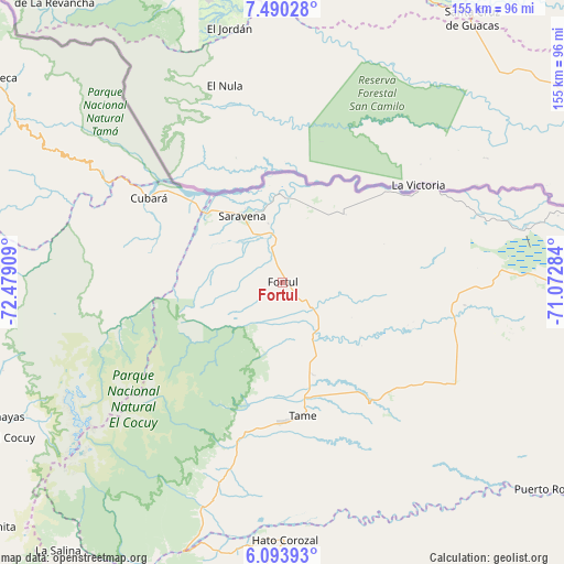
Fortul GPS coordinates[2]
6° 47' 33.396" North, 71° 46' 33.456" West
| Map corner | latitude | longitude |
|---|---|---|
| Upper-left | 7.49028°, | -72.47909° |
| Center: | 6.79261°, | -71.77596° |
| Lower-right: | 6.09393°, | -71.07284° |
| Map W x H: | 155.3×155.3 km | = 96.5×96.5mi |
| max Lat: | 13.38166° ⇑27.5% North |
| Fortul: | 6.79261° |
| min Lat: | ⇓72.5% South -4.21528° |
| min Long | Fortul | max Long |
| -81.70636° | -71.77596° | -67.06996° |
| W 98.3%⇐ | ⇒1.7% E |
Elevation
Elevation of Fortul is 241 m = 791 ft, and this is 908.3 m = 2980 ft below average elevation for this country.
| Max E: |
3342 m = 10965 ft | 72.5% |
| Avg. | 1149.3 m = 3771 ft | |
| Fortul | 241 m = 791 ft | |
Min E: |
1 m = 3 ft | 27.5% |
See also: Colombia elevation on elevation.city.
Geographical zone
Fortul is located in North Torrid zone (between Equator and Tropic of Cancer). Distance of Equator is 755.3 km =469.3 mi to South.| Distance of | km | miles | from Fortul |
|---|---|---|---|
| North Pole | 9251.8 | 5748.8 | to North |
| Arctic Circle | 6645.9 | 4129.6 | to North |
| Tropic Cancer | 1850.7 | 1150 | to North |
| Equator | 755.3 | 469.3 | to South |


Nearby cities:
15 places around Fortul: (largest is in red/bold)
• Arauquita
46.5 km =28.9 mi,  55°
55°
• Carcasí
95.7 km =59.5 mi,  258°
258°
• Chiscas
84.6 km =52.6 mi,  251°
251°
• Cubará
43.4 km =27 mi,  303°
303°
• El Cocuy
85.5 km =53.1 mi,  240°
240°
• El Espino
86.8 km =53.9 mi, 246°
• Guacamayas
88.5 km =55 mi, 245°
• Güicán
79.4 km =49.3 mi, 242°
• Macaravita
95.7 km =59.5 mi, 250°
• Municipio Hato Corozal
70.7 km =43.9 mi,  178°
178°
• Panqueba
85.1 km =52.9 mi, 243°
• Puerto Rondón
93.9 km =58.3 mi,  127°
127°
• Saravena
22.3 km =13.9 mi,  328°
328°
• Sácama
93.1 km =57.8 mi,  214°
214°
• Tame
37.2 km =23.1 mi,  173°
173°
Sources, notices
• [Note1] Compared only with cities in Colombia existing in our database
• [Src1] Map data: © OpenStreetMap contributors (CC-BY-SA)
• [Src2] Other city data from geonames.org with taken over terms of usage.
• [Src3] Geographical zone / Annual Mean Temperature by Robert A. Rohde @ Wikipedia
