San Sebastián geodata
San Sebastián (Cauca) is a seat of a second-order administrative division; located in Colombia in America/Bogota (GMT-5) time zone. With population of 931 people, there are 958 cities with bigger population in this country. Compared to other cities in Colombia, 91.3% of cities are located further ↑North; 90.3% of cities are located further →East and 80.9% of cities have lower elevation than San Sebastián. Note1


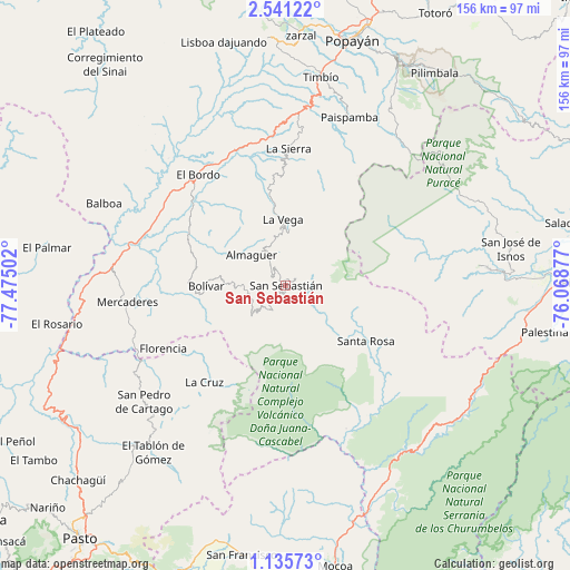
San Sebastián GPS coordinates[2]
1° 50' 18.996" North, 76° 46' 18.804" West
| Map corner | latitude | longitude |
|---|---|---|
| Upper-left | 2.54122°, | -77.47502° |
| Center: | 1.83861°, | -76.77189° |
| Lower-right: | 1.13573°, | -76.06877° |
| Map W x H: | 156.3×156.3 km | = 97.1×97.1mi |
| max Lat: | 13.38166° ⇑91.3% North |
| San Sebastián: | 1.83861° |
| min Lat: | ⇓8.7% South -4.21528° |
| min Long | San Sebastián | max Long |
| -81.70636° | -76.77189° | -67.06996° |
| W 9.7%⇐ | ⇒90.3% E |
Elevation
Elevation of San Sebastián is 2099 m = 6886 ft, and this is 949.7 m = 3116 ft above average elevation for this country.
| Max E: |
3342 m = 10965 ft | 19.1% |
| San Sebastián | 2099 m 6886 ft | |
| Avg. | 1149.3 m = 3771 ft | |
Min E: |
1 m = 3 ft | 80.9% |
See also: Colombia elevation on elevation.city.
Geographical zone
San Sebastián is located in North Torrid zone (between Equator and Tropic of Cancer). Distance of Equator is 204.4 km =127 mi to South.| Distance of | km | miles | from San Sebastián |
|---|---|---|---|
| North Pole | 9802.6 | 6091.1 | to North |
| Arctic Circle | 7196.7 | 4471.8 | to North |
| Tropic Cancer | 2401.5 | 1492.2 | to North |
| Equator | 204.4 | 127 | to South |


Nearby cities:
15 places around San Sebastián: (largest is in red/bold)
• Almaguer
12.5 km =7.8 mi,  312°
312°
• Belén
41.5 km =25.8 mi,  229°
229°
• Bolívar
21.9 km =13.6 mi,  270°
270°
• El Bordo
38.8 km =24.1 mi,  322°
322°
• Florencia
37.7 km =23.4 mi,  242°
242°
• Génova
35 km =21.7 mi, 231°
• La Cruz
34.4 km =21.4 mi,  220°
220°
• La Sierra
37.8 km =23.5 mi,  1°
1°
• La Vega
18.2 km =11.3 mi,  357°
357°
• Mercaderes
44.5 km =27.7 mi,  264°
264°
• Patía
40.4 km =25.1 mi, 309°
• Rosas
47.1 km =29.3 mi, 4°
• San Pablo
32.6 km =20.3 mi, 235°
• Santa Rosa
26.7 km =16.6 mi,  124°
124°
• Sucre
27.9 km =17.3 mi, 322°
Sources, notices
• [Note1] Compared only with cities in Colombia existing in our database
• [Src1] Map data: © OpenStreetMap contributors (CC-BY-SA)
• [Src2] Other city data from geonames.org with taken over terms of usage.
• [Src3] Geographical zone / Annual Mean Temperature by Robert A. Rohde @ Wikipedia
