Santa Rosa geodata
Santa Rosa (Cauca) is a seat of a second-order administrative division; located in Colombia in America/Bogota (GMT-5) time zone. In our database, there are 1053 cities with bigger population. Compared to other cities in Colombia, 91.9% of cities are located further ↑North; 87.9% of cities are located further →East and 69.8% of cities have lower elevation than Santa Rosa. Note1


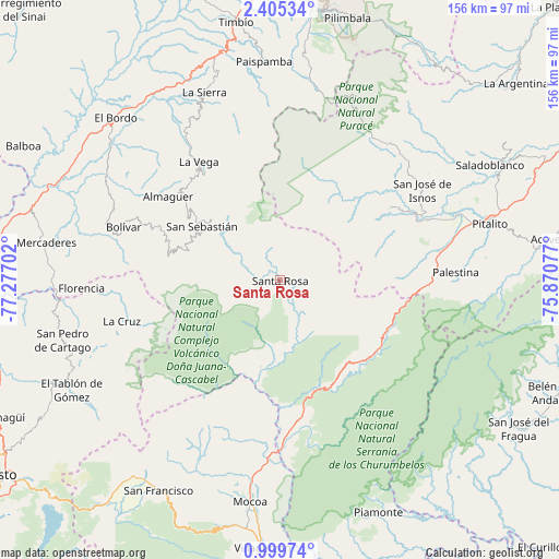
Santa Rosa GPS coordinates[2]
1° 42' 9.612" North, 76° 34' 26.004" West
| Map corner | latitude | longitude |
|---|---|---|
| Upper-left | 2.40534°, | -77.27702° |
| Center: | 1.70267°, | -76.57389° |
| Lower-right: | 0.99974°, | -75.87077° |
| Map W x H: | 156.3×156.3 km | = 97.1×97.1mi |
| max Lat: | 13.38166° ⇑91.9% North |
| Santa Rosa: | 1.70267° |
| min Lat: | ⇓8.1% South -4.21528° |
| min Long | Santa Rosa | max Long |
| -81.70636° | -76.57389° | -67.06996° |
| W 12.1%⇐ | ⇒87.9% E |
Elevation
Elevation of Santa Rosa is 1727 m = 5666 ft, and this is 577.7 m = 1895 ft above average elevation for this country.
| Max E: |
3342 m = 10965 ft | 30.2% |
| Santa Rosa | 1727 m 5666 ft | |
| Avg. | 1149.3 m = 3771 ft | |
Min E: |
1 m = 3 ft | 69.8% |
See also: Colombia elevation on elevation.city.
Geographical zone
Santa Rosa is located in North Torrid zone (between Equator and Tropic of Cancer). Distance of Equator is 189.3 km =117.6 mi to South.| Distance of | km | miles | from Santa Rosa |
|---|---|---|---|
| North Pole | 9817.7 | 6100.4 | to North |
| Arctic Circle | 7211.9 | 4481.3 | to North |
| Tropic Cancer | 2416.6 | 1501.6 | to North |
| Equator | 189.3 | 117.6 | to South |


Nearby cities:
15 places around Santa Rosa: (largest is in red/bold)
• Almaguer
39.1 km =24.3 mi,  307°
307°
• Belén
54.7 km =34 mi,  257°
257°
• Bolívar
46.5 km =28.9 mi,  289°
289°
• Florencia
55.5 km =34.5 mi,  267°
267°
• Génova
49.9 km =31 mi, 262°
• Isnos
45.2 km =28.1 mi,  55°
55°
• Isnos
47.5 km =29.5 mi, 58°
• La Cruz
45.6 km =28.3 mi, 255°
• La Vega
40.3 km =25 mi,  325°
325°
• Palestina
48.9 km =30.4 mi,  87°
87°
• San Agustín
39.3 km =24.4 mi, 60°
• San Bernardo
56.5 km =35.1 mi,  248°
248°
• San Pablo
49 km =30.4 mi, 266°
• San Sebastián
26.7 km =16.6 mi,  304°
304°
• Sucre
53.9 km =33.5 mi, 313°
Sources, notices
• [Note1] Compared only with cities in Colombia existing in our database
• [Src1] Map data: © OpenStreetMap contributors (CC-BY-SA)
• [Src2] Other city data from geonames.org with taken over terms of usage.
• [Src3] Geographical zone / Annual Mean Temperature by Robert A. Rohde @ Wikipedia
