Caracolí geodata
Caracolí (Antioquia) is a seat of a second-order administrative division; located in Colombia in America/Bogota (GMT-5) time zone. With population of 3,120 people, there are 670 cities with bigger population in this country. Compared to other cities in Colombia, 66.6% of cities are located further ↓South; 51.9% of cities are located further ←West and 61.4% of cities have higher elevation than Caracolí. Note1


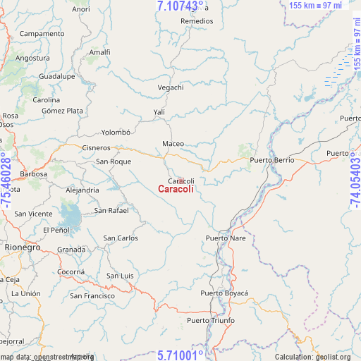
Caracolí GPS coordinates[2]
6° 24' 33.12" North, 74° 45' 25.74" West
| Map corner | latitude | longitude |
|---|---|---|
| Upper-left | 7.10743°, | -75.46028° |
| Center: | 6.4092°, | -74.75715° |
| Lower-right: | 5.71001°, | -74.05403° |
| Map W x H: | 155.4×155.4 km | = 96.6×96.6mi |
| max Lat: | 13.38166° ⇑33.4% North |
| Caracolí: | 6.4092° |
| min Lat: | ⇓66.6% South -4.21528° |
| min Long | Caracolí | max Long |
| -81.70636° | -74.75715° | -67.06996° |
| W 51.9%⇐ | ⇒48.1% E |
Elevation
Elevation of Caracolí is 643 m = 2110 ft, and this is 506.3 m = 1661 ft below average elevation for this country.
| Max E: |
3342 m = 10965 ft | 61.4% |
| Avg. | 1149.3 m = 3771 ft | |
| Caracolí | 643 m = 2110 ft | |
Min E: |
1 m = 3 ft | 38.6% |
See also: Colombia elevation on elevation.city.
Geographical zone
Caracolí is located in North Torrid zone (between Equator and Tropic of Cancer). Distance of Equator is 712.6 km =442.8 mi to South.| Distance of | km | miles | from Caracolí |
|---|---|---|---|
| North Pole | 9294.4 | 5775.3 | to North |
| Arctic Circle | 6688.5 | 4156 | to North |
| Tropic Cancer | 1893.3 | 1176.4 | to North |
| Equator | 712.6 | 442.8 | to South |


Nearby cities:
15 places around Caracolí: (largest is in red/bold)
• Alejandría
42.5 km =26.4 mi,  265°
265°
• Cisneros
39.3 km =24.4 mi,  291°
291°
• Concepción
55.4 km =34.4 mi, 268°
• Guatapé
48.9 km =30.4 mi,  246°
246°
• Maceo
16.2 km =10.1 mi,  348°
348°
• Puerto Berrío
40.2 km =25 mi,  76°
76°
• Puerto Boyacá
51.8 km =32.2 mi,  158°
158°
• San Carlos
35.9 km =22.3 mi,  226°
226°
• San Luis
48.3 km =30 mi,  212°
212°
• San Rafael
32.3 km =20.1 mi, 246°
• San Roque
30.2 km =18.8 mi, 286°
• Santo Domingo
45.7 km =28.4 mi,  278°
278°
• Vegachí
39.4 km =24.5 mi, 353°
• Yalí
30.7 km =19.1 mi,  343°
343°
• Yolombó
35.1 km =21.8 mi,  306°
306°
Sources, notices
• [Note1] Compared only with cities in Colombia existing in our database
• [Src1] Map data: © OpenStreetMap contributors (CC-BY-SA)
• [Src2] Other city data from geonames.org with taken over terms of usage.
• [Src3] Geographical zone / Annual Mean Temperature by Robert A. Rohde @ Wikipedia
