Ocaña geodata
Ocaña (Norte de Santander) is a seat of a second-order administrative division; located in Colombia in America/Bogota (GMT-5) time zone. With population of 83,511 people, there are 50 cities with bigger population in this country. Compared to other cities in Colombia, 81.9% of cities are located further ↓South; 79% of cities are located further ←West and 51.8% of cities have lower elevation than Ocaña. Note1


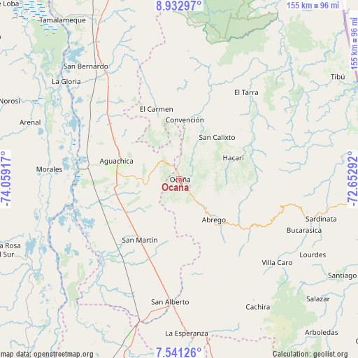
Ocaña GPS coordinates[2]
8° 14' 15.828" North, 73° 21' 21.744" West
| Map corner | latitude | longitude |
|---|---|---|
| Upper-left | 8.93297°, | -74.05917° |
| Center: | 8.23773°, | -73.35604° |
| Lower-right: | 7.54126°, | -72.65292° |
| Map W x H: | 154.7×154.7 km | = 96.1×96.1mi |
| max Lat: | 13.38166° ⇑18.1% North |
| Ocaña: | 8.23773° |
| min Lat: | ⇓81.9% South -4.21528° |
| min Long | Ocaña | max Long |
| -81.70636° | -73.35604° | -67.06996° |
| W 79%⇐ | ⇒21% E |
Elevation
Elevation of Ocaña is 1197 m = 3927 ft, and this is 47.7 m = 156 ft above average elevation for this country.
| Max E: |
3342 m = 10965 ft | 48.2% |
| Ocaña | 1197 m 3927 ft | |
| Avg. | 1149.3 m = 3771 ft | |
Min E: |
1 m = 3 ft | 51.8% |
See also: Ocaña elevation on elevation.city.
Geographical zone
Ocaña is located in North Torrid zone (between Equator and Tropic of Cancer). Distance of Equator is 915.9 km =569.1 mi to South.| Distance of | km | miles | from Ocaña |
|---|---|---|---|
| North Pole | 9091.1 | 5648.9 | to North |
| Arctic Circle | 6485.2 | 4029.7 | to North |
| Tropic Cancer | 1690 | 1050.1 | to North |
| Equator | 915.9 | 569.1 | to South |


Nearby cities:
15 places around Ocaña: (largest is in red/bold)
• Aguachica
29.7 km =18.5 mi,  285°
285°
• Convención
25.8 km =16 mi,  4°
4°
• El Carmen
32 km =19.9 mi,  341°
341°
• El Tarra
47.3 km =29.4 mi,  37°
37°
• Gamarra
43.6 km =27.1 mi,  282°
282°
• González
17.1 km =10.6 mi,  351°
351°
• Hacarí
24.7 km =15.3 mi,  67°
67°
• La Playa
13.2 km =8.2 mi,  101°
101°
• Río de Oro
6.8 km =4.2 mi,  332°
332°
• San Alberto
53.1 km =33 mi,  184°
184°
• San Calixto
24.5 km =15.2 mi, 41°
• San Martín
31.3 km =19.4 mi,  213°
213°
• Teorama
23.3 km =14.5 mi,  18°
18°
• Villa Caro
55.6 km =34.5 mi,  130°
130°
• Ábrego
23 km =14.3 mi,  139°
139°
Sources, notices
• [Note1] Compared only with cities in Colombia existing in our database
• [Src1] Map data: © OpenStreetMap contributors (CC-BY-SA)
• [Src2] Other city data from geonames.org with taken over terms of usage.
• [Src3] Geographical zone / Annual Mean Temperature by Robert A. Rohde @ Wikipedia
