Río Viejo geodata
Río Viejo (Bolívar) is a seat of a second-order administrative division; located in Colombia in America/Bogota (GMT-5) time zone. With population of 6,963 people, there are 409 cities with bigger population in this country. Compared to other cities in Colombia, 84.4% of cities are located further ↓South; 68.8% of cities are located further ←West and 88.5% of cities have higher elevation than Río Viejo. Note1


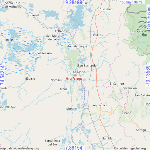
Río Viejo GPS coordinates[2]
8° 35' 14.64" North, 73° 50' 20.436" West
| Map corner | latitude | longitude |
|---|---|---|
| Upper-left | 9.28199°, | -74.54214° |
| Center: | 8.5874°, | -73.83901° |
| Lower-right: | 7.89154°, | -73.13589° |
| Map W x H: | 154.6×154.6 km | = 96.1×96.1mi |
| max Lat: | 13.38166° ⇑15.6% North |
| Río Viejo: | 8.5874° |
| min Lat: | ⇓84.4% South -4.21528° |
| min Long | Río Viejo | max Long |
| -81.70636° | -73.83901° | -67.06996° |
| W 68.8%⇐ | ⇒31.2% E |
Elevation
Elevation of Río Viejo is 37 m = 121 ft, and this is 1112.3 m = 3649 ft below average elevation for this country.
| Max E: |
3342 m = 10965 ft | 88.5% |
| Avg. | 1149.3 m = 3771 ft | |
| Río Viejo | 37 m = 121 ft | |
Min E: |
1 m = 3 ft | 11.5% |
See also: Colombia elevation on elevation.city.
Geographical zone
Río Viejo is located in North Torrid zone (between Equator and Tropic of Cancer). Distance of Equator is 954.8 km =593.3 mi to South.| Distance of | km | miles | from Río Viejo |
|---|---|---|---|
| North Pole | 9052.2 | 5624.8 | to North |
| Arctic Circle | 6446.3 | 4005.5 | to North |
| Tropic Cancer | 1651.1 | 1025.9 | to North |
| Equator | 954.8 | 593.3 | to South |


Nearby cities:
15 places around Río Viejo: (largest is in red/bold)
• Aguachica
39.5 km =24.5 mi,  141°
141°
• Altos del Rosario
42.5 km =26.4 mi,  302°
302°
• Arenal
18.3 km =11.4 mi,  218°
218°
• El Carmen
43.9 km =27.3 mi,  101°
101°
• El Peñón
46 km =28.6 mi,  345°
345°
• Gamarra
31.3 km =19.4 mi,  160°
160°
• La Gloria
5.3 km =3.3 mi,  48°
48°
• Morales
34.9 km =21.7 mi,  185°
185°
• Norosí
22.8 km =14.2 mi,  252°
252°
• Pailitas
47.3 km =29.4 mi,  29°
29°
• Pelaya
22.2 km =13.8 mi,  59°
59°
• Regidor
8.9 km =5.5 mi,  12°
12°
• San Martín de Loba
44.6 km =27.7 mi,  330°
330°
• Tamalameque
29.6 km =18.4 mi, 5°
• Tiquisio
46.8 km =29.1 mi,  265°
265°
Sources, notices
• [Note1] Compared only with cities in Colombia existing in our database
• [Src1] Map data: © OpenStreetMap contributors (CC-BY-SA)
• [Src2] Other city data from geonames.org with taken over terms of usage.
• [Src3] Geographical zone / Annual Mean Temperature by Robert A. Rohde @ Wikipedia
