Pelaya geodata
Pelaya (Cesar) is a seat of a second-order administrative division; located in Colombia in America/Bogota (GMT-5) time zone. With population of 11,306 people, there are 267 cities with bigger population in this country. Compared to other cities in Colombia, 84.9% of cities are located further ↓South; 72.2% of cities are located further ←West and 83.7% of cities have higher elevation than Pelaya. Note1


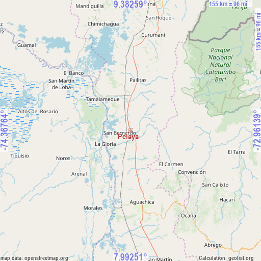
Pelaya GPS coordinates[2]
8° 41' 17.484" North, 73° 39' 52.236" West
| Map corner | latitude | longitude |
|---|---|---|
| Upper-left | 9.38259°, | -74.36764° |
| Center: | 8.68819°, | -73.66451° |
| Lower-right: | 7.99251°, | -72.96139° |
| Map W x H: | 154.6×154.6 km | = 96.1×96.1mi |
| max Lat: | 13.38166° ⇑15.1% North |
| Pelaya: | 8.68819° |
| min Lat: | ⇓84.9% South -4.21528° |
| min Long | Pelaya | max Long |
| -81.70636° | -73.66451° | -67.06996° |
| W 72.2%⇐ | ⇒27.8% E |
Elevation
Elevation of Pelaya is 73 m = 240 ft, and this is 1076.3 m = 3531 ft below average elevation for this country.
| Max E: |
3342 m = 10965 ft | 83.7% |
| Avg. | 1149.3 m = 3771 ft | |
| Pelaya | 73 m = 240 ft | |
Min E: |
1 m = 3 ft | 16.3% |
See also: Colombia elevation on elevation.city.
Geographical zone
Pelaya is located in North Torrid zone (between Equator and Tropic of Cancer). Distance of Equator is 966 km =600.2 mi to South.| Distance of | km | miles | from Pelaya |
|---|---|---|---|
| North Pole | 9041 | 5617.8 | to North |
| Arctic Circle | 6435.1 | 3998.6 | to North |
| Tropic Cancer | 1639.9 | 1019 | to North |
| Equator | 966 | 600.2 | to South |


Nearby cities:
15 places around Pelaya: (largest is in red/bold)
• Aguachica
42.6 km =26.5 mi,  172°
172°
• Arenal
39.8 km =24.7 mi,  230°
230°
• Convención
43.4 km =27 mi,  124°
124°
• El Banco
48.8 km =30.3 mi,  315°
315°
• El Carmen
30.9 km =19.2 mi,  129°
129°
• El Peñón
45.5 km =28.3 mi, 316°
• Gamarra
41.5 km =25.8 mi,  191°
191°
• González
45.6 km =28.3 mi,  136°
136°
• La Gloria
17 km =10.6 mi,  243°
243°
• Norosí
44.7 km =27.8 mi,  246°
246°
• Pailitas
30.1 km =18.7 mi,  8°
8°
• Regidor
17.4 km =10.8 mi,  261°
261°
• Río Viejo
22.2 km =13.8 mi, 239°
• San Martín de Loba
49.6 km =30.8 mi,  303°
303°
• Tamalameque
24.4 km =15.2 mi, 318°
Sources, notices
• [Note1] Compared only with cities in Colombia existing in our database
• [Src1] Map data: © OpenStreetMap contributors (CC-BY-SA)
• [Src2] Other city data from geonames.org with taken over terms of usage.
• [Src3] Geographical zone / Annual Mean Temperature by Robert A. Rohde @ Wikipedia
