Arenal geodata
Arenal (Bolívar) is a seat of a second-order administrative division; located in Colombia in America/Bogota (GMT-5) time zone. With population of 5,346 people, there are 484 cities with bigger population in this country. Compared to other cities in Colombia, 83.5% of cities are located further ↓South; 66.3% of cities are located further ←West and 87.3% of cities have higher elevation than Arenal. Note1


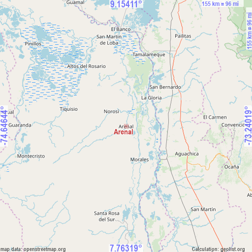
Arenal GPS coordinates[2]
8° 27' 33.408" North, 73° 56' 35.916" West
| Map corner | latitude | longitude |
|---|---|---|
| Upper-left | 9.15411°, | -74.64644° |
| Center: | 8.45928°, | -73.94331° |
| Lower-right: | 7.76319°, | -73.24019° |
| Map W x H: | 154.7×154.7 km | = 96.1×96.1mi |
| max Lat: | 13.38166° ⇑16.5% North |
| Arenal: | 8.45928° |
| min Lat: | ⇓83.5% South -4.21528° |
| min Long | Arenal | max Long |
| -81.70636° | -73.94331° | -67.06996° |
| W 66.3%⇐ | ⇒33.7% E |
Elevation
Elevation of Arenal is 44 m = 144 ft, and this is 1105.3 m = 3626 ft below average elevation for this country.
| Max E: |
3342 m = 10965 ft | 87.3% |
| Avg. | 1149.3 m = 3771 ft | |
| Arenal | 44 m = 144 ft | |
Min E: |
1 m = 3 ft | 12.7% |
See also: Colombia elevation on elevation.city.
Geographical zone
Arenal is located in North Torrid zone (between Equator and Tropic of Cancer). Distance of Equator is 940.6 km =584.5 mi to South.| Distance of | km | miles | from Arenal |
|---|---|---|---|
| North Pole | 9066.5 | 5633.7 | to North |
| Arctic Circle | 6460.6 | 4014.4 | to North |
| Tropic Cancer | 1665.3 | 1034.8 | to North |
| Equator | 940.6 | 584.5 | to South |


Nearby cities:
15 places around Arenal: (largest is in red/bold)
• Aguachica
39.7 km =24.7 mi,  115°
115°
• Altos del Rosario
44.3 km =27.5 mi,  326°
326°
• El Carmen
54.8 km =34.1 mi,  84°
84°
• Gamarra
26.8 km =16.7 mi, 124°
• La Gloria
23.5 km =14.6 mi,  41°
41°
• Morales
22 km =13.7 mi,  158°
158°
• Norosí
12.8 km =8 mi,  306°
306°
• Pelaya
39.8 km =24.7 mi,  50°
50°
• Regidor
26.6 km =16.5 mi,  30°
30°
• Río Viejo
18.3 km =11.4 mi, 38°
• San Martín de Loba
54.1 km =33.6 mi,  348°
348°
• Santa Rosa del Sur
56.4 km =35 mi,  192°
192°
• Simití
55.7 km =34.6 mi,  180°
180°
• Tamalameque
46 km =28.6 mi,  18°
18°
• Tiquisio
36.8 km =22.9 mi,  287°
287°
Sources, notices
• [Note1] Compared only with cities in Colombia existing in our database
• [Src1] Map data: © OpenStreetMap contributors (CC-BY-SA)
• [Src2] Other city data from geonames.org with taken over terms of usage.
• [Src3] Geographical zone / Annual Mean Temperature by Robert A. Rohde @ Wikipedia
