La Gloria geodata
La Gloria (Cesar) is a seat of a second-order administrative division; located in Colombia in America/Bogota (GMT-5) time zone. With population of 6,810 people, there are 416 cities with bigger population in this country. Compared to other cities in Colombia, 84.5% of cities are located further ↓South; 69.8% of cities are located further ←West and 88.7% of cities have higher elevation than La Gloria. Note1


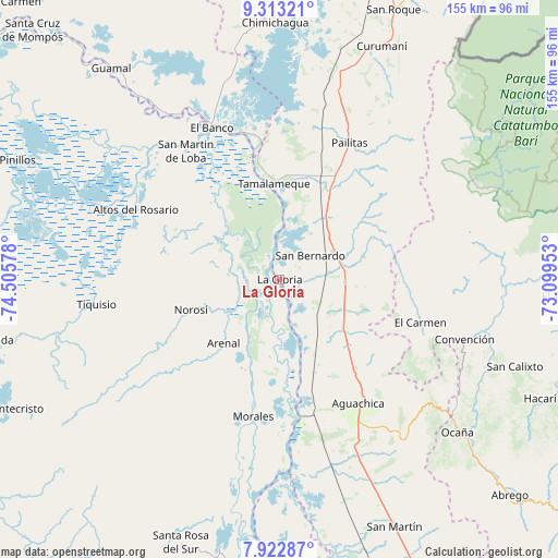
La Gloria GPS coordinates[2]
8° 37' 7.248" North, 73° 48' 9.54" West
| Map corner | latitude | longitude |
|---|---|---|
| Upper-left | 9.31321°, | -74.50578° |
| Center: | 8.61868°, | -73.80265° |
| Lower-right: | 7.92287°, | -73.09953° |
| Map W x H: | 154.6×154.6 km | = 96.1×96.1mi |
| max Lat: | 13.38166° ⇑15.5% North |
| La Gloria: | 8.61868° |
| min Lat: | ⇓84.5% South -4.21528° |
| min Long | La Gloria | max Long |
| -81.70636° | -73.80265° | -67.06996° |
| W 69.8%⇐ | ⇒30.2% E |
Elevation
Elevation of La Gloria is 36 m = 118 ft, and this is 1113.3 m = 3653 ft below average elevation for this country.
| Max E: |
3342 m = 10965 ft | 88.7% |
| Avg. | 1149.3 m = 3771 ft | |
| La Gloria | 36 m = 118 ft | |
Min E: |
1 m = 3 ft | 11.3% |
See also: Colombia elevation on elevation.city.
Geographical zone
La Gloria is located in North Torrid zone (between Equator and Tropic of Cancer). Distance of Equator is 958.3 km =595.5 mi to South.| Distance of | km | miles | from La Gloria |
|---|---|---|---|
| North Pole | 9048.8 | 5622.7 | to North |
| Arctic Circle | 6442.9 | 4003.4 | to North |
| Tropic Cancer | 1647.6 | 1023.8 | to North |
| Equator | 958.3 | 595.5 | to South |


Nearby cities:
15 places around La Gloria: (largest is in red/bold)
• Aguachica
40.1 km =24.9 mi,  149°
149°
• Altos del Rosario
44.3 km =27.5 mi,  295°
295°
• Arenal
23.5 km =14.6 mi,  221°
221°
• El Banco
46.6 km =29 mi,  335°
335°
• El Carmen
40.8 km =25.4 mi,  107°
107°
• El Peñón
43.9 km =27.3 mi, 338°
• Gamarra
33.6 km =20.9 mi,  168°
168°
• Morales
38.9 km =24.2 mi,  190°
190°
• Norosí
27.7 km =17.2 mi,  248°
248°
• Pailitas
42.3 km =26.3 mi,  27°
27°
• Pelaya
17 km =10.6 mi,  63°
63°
• Regidor
5.6 km =3.5 mi, 338°
• Río Viejo
5.3 km =3.3 mi,  228°
228°
• San Martín de Loba
43.9 km =27.3 mi,  323°
323°
• Tamalameque
26 km =16.2 mi,  357°
357°
Sources, notices
• [Note1] Compared only with cities in Colombia existing in our database
• [Src1] Map data: © OpenStreetMap contributors (CC-BY-SA)
• [Src2] Other city data from geonames.org with taken over terms of usage.
• [Src3] Geographical zone / Annual Mean Temperature by Robert A. Rohde @ Wikipedia
