Aguachica geodata
Aguachica (Cesar) is a seat of a second-order administrative division; located in Colombia in America/Bogota (GMT-5) time zone. With population of 73,360 people, there are 54 cities with bigger population in this country. Compared to other cities in Colombia, 82.6% of cities are located further ↓South; 73.1% of cities are located further ←West and 76.6% of cities have higher elevation than Aguachica. Note1


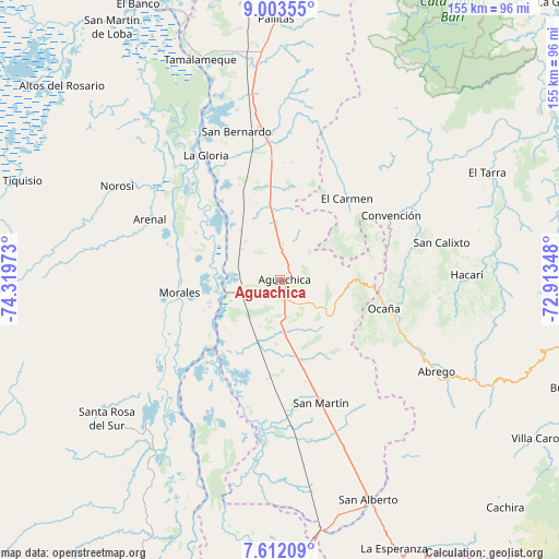
Aguachica GPS coordinates[2]
8° 18' 30.384" North, 73° 36' 59.76" West
| Map corner | latitude | longitude |
|---|---|---|
| Upper-left | 9.00355°, | -74.31973° |
| Center: | 8.30844°, | -73.6166° |
| Lower-right: | 7.61209°, | -72.91348° |
| Map W x H: | 154.7×154.7 km | = 96.1×96.1mi |
| max Lat: | 13.38166° ⇑17.4% North |
| Aguachica: | 8.30844° |
| min Lat: | ⇓82.6% South -4.21528° |
| min Long | Aguachica | max Long |
| -81.70636° | -73.6166° | -67.06996° |
| W 73.1%⇐ | ⇒26.9% E |
Elevation
Elevation of Aguachica is 164 m = 538 ft, and this is 985.3 m = 3233 ft below average elevation for this country.
| Max E: |
3342 m = 10965 ft | 76.6% |
| Avg. | 1149.3 m = 3771 ft | |
| Aguachica | 164 m = 538 ft | |
Min E: |
1 m = 3 ft | 23.4% |
See also: Aguachica elevation on elevation.city.
Geographical zone
Aguachica is located in North Torrid zone (between Equator and Tropic of Cancer). Distance of Equator is 923.8 km =574 mi to South.| Distance of | km | miles | from Aguachica |
|---|---|---|---|
| North Pole | 9083.2 | 5644 | to North |
| Arctic Circle | 6477.4 | 4024.9 | to North |
| Tropic Cancer | 1682.1 | 1045.2 | to North |
| Equator | 923.8 | 574 | to South |


Nearby cities:
15 places around Aguachica: (largest is in red/bold)
• Arenal
39.7 km =24.7 mi,  295°
295°
• Convención
35.5 km =22.1 mi,  59°
59°
• El Carmen
29.2 km =18.1 mi,  39°
39°
• Gamarra
14 km =8.7 mi,  276°
276°
• González
27.6 km =17.1 mi,  70°
70°
• La Gloria
40.1 km =24.9 mi,  329°
329°
• La Playa
43 km =26.7 mi,  104°
104°
• Morales
28 km =17.4 mi,  262°
262°
• Ocaña
29.7 km =18.5 mi,  105°
105°
• Pelaya
42.6 km =26.5 mi,  352°
352°
• Regidor
45.7 km =28.4 mi, 330°
• Río Viejo
39.5 km =24.5 mi,  321°
321°
• Río de Oro
25.6 km =15.9 mi,  94°
94°
• San Martín
36 km =22.4 mi,  161°
161°
• Teorama
38.7 km =24 mi, 68°
Sources, notices
• [Note1] Compared only with cities in Colombia existing in our database
• [Src1] Map data: © OpenStreetMap contributors (CC-BY-SA)
• [Src2] Other city data from geonames.org with taken over terms of usage.
• [Src3] Geographical zone / Annual Mean Temperature by Robert A. Rohde @ Wikipedia
