Puerto Santander geodata
Puerto Santander (Norte de Santander) is a seat of a second-order administrative division; located in Colombia in America/Bogota (GMT-5) time zone. With population of 16,275 people, there are 212 cities with bigger population in this country. Compared to other cities in Colombia, 83% of cities are located further ↓South; 96.8% of cities are located further ←West and 86.3% of cities have higher elevation than Puerto Santander. Note1


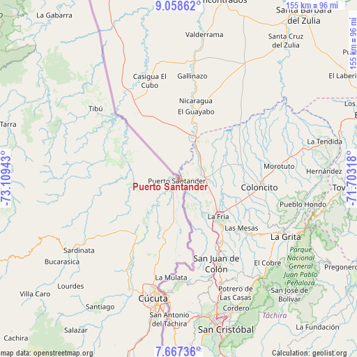
Puerto Santander GPS coordinates[2]
8° 21' 48.996" North, 72° 24' 22.68" West
| Map corner | latitude | longitude |
|---|---|---|
| Upper-left | 9.05862°, | -73.10943° |
| Center: | 8.36361°, | -72.4063° |
| Lower-right: | 7.66736°, | -71.70318° |
| Map W x H: | 154.7×154.7 km | = 96.1×96.1mi |
| max Lat: | 13.38166° ⇑17% North |
| Puerto Santander: | 8.36361° |
| min Lat: | ⇓83% South -4.21528° |
| min Long | Puerto Santande | max Long |
| -81.70636° | -72.4063° | -67.06996° |
| W 96.8%⇐ | ⇒3.2% E |
Elevation
Elevation of Puerto Santander is 50 m = 164 ft, and this is 1099.3 m = 3607 ft below average elevation for this country.
| Max E: |
3342 m = 10965 ft | 86.3% |
| Avg. | 1149.3 m = 3771 ft | |
| Puerto Santander | 50 m = 164 ft | |
Min E: |
1 m = 3 ft | 13.7% |
See also: Colombia elevation on elevation.city.
Geographical zone
Puerto Santander is located in North Torrid zone (between Equator and Tropic of Cancer). Distance of Equator is 929.9 km =577.8 mi to South.| Distance of | km | miles | from Puerto Santander |
|---|---|---|---|
| North Pole | 9077.1 | 5640.2 | to North |
| Arctic Circle | 6471.2 | 4021 | to North |
| Tropic Cancer | 1676 | 1041.4 | to North |
| Equator | 929.9 | 577.8 | to South |


Nearby cities:
15 places around Puerto Santander: (largest is in red/bold)
• Bucarasica
62 km =38.5 mi,  234°
234°
• Cúcuta
53.4 km =33.2 mi,  192°
192°
• Durania
77.4 km =48.1 mi,  200°
200°
• El Tarra
79.3 km =49.3 mi,  287°
287°
• El Zulia
52.5 km =32.6 mi, 204°
• Gramalote
68.2 km =42.4 mi,  219°
219°
• La Esperanza
18.2 km =11.3 mi, 200°
• Los Patios
59.4 km =36.9 mi, 190°
• Lourdes
66.2 km =41.1 mi, 225°
• San Cayetano
59.2 km =36.8 mi, 203°
• Santiago
65.2 km =40.5 mi,  211°
211°
• Sardinata
53.5 km =33.2 mi, 234°
• Tibú
47.4 km =29.5 mi,  310°
310°
• Villa Caro
79.8 km =49.6 mi, 231°
• Villa del Rosario
59.4 km =36.9 mi, 187°
Sources, notices
• [Note1] Compared only with cities in Colombia existing in our database
• [Src1] Map data: © OpenStreetMap contributors (CC-BY-SA)
• [Src2] Other city data from geonames.org with taken over terms of usage.
• [Src3] Geographical zone / Annual Mean Temperature by Robert A. Rohde @ Wikipedia
