Tibú geodata
Tibú (Norte de Santander) is a seat of a second-order administrative division; located in Colombia in America/Bogota (GMT-5) time zone. With population of 13,565 people, there are 236 cities with bigger population in this country. Compared to other cities in Colombia, 84.6% of cities are located further ↓South; 91.7% of cities are located further ←West and 84% of cities have higher elevation than Tibú. Note1


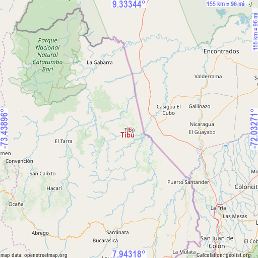
Tibú GPS coordinates[2]
8° 38' 20.22" North, 72° 44' 8.988" West
| Map corner | latitude | longitude |
|---|---|---|
| Upper-left | 9.33344°, | -73.43896° |
| Center: | 8.63895°, | -72.73583° |
| Lower-right: | 7.94318°, | -72.03271° |
| Map W x H: | 154.6×154.6 km | = 96.1×96.1mi |
| max Lat: | 13.38166° ⇑15.4% North |
| Tibú: | 8.63895° |
| min Lat: | ⇓84.6% South -4.21528° |
| min Long | Tibú | max Long |
| -81.70636° | -72.73583° | -67.06996° |
| W 91.7%⇐ | ⇒8.3% E |
Elevation
Elevation of Tibú is 68 m = 223 ft, and this is 1081.3 m = 3548 ft below average elevation for this country.
| Max E: |
3342 m = 10965 ft | 84% |
| Avg. | 1149.3 m = 3771 ft | |
| Tibú | 68 m = 223 ft | |
Min E: |
1 m = 3 ft | 16% |
See also: Colombia elevation on elevation.city.
Geographical zone
Tibú is located in North Torrid zone (between Equator and Tropic of Cancer). Distance of Equator is 960.6 km =596.9 mi to South.| Distance of | km | miles | from Tibú |
|---|---|---|---|
| North Pole | 9046.5 | 5621.2 | to North |
| Arctic Circle | 6440.6 | 4002 | to North |
| Tropic Cancer | 1645.4 | 1022.4 | to North |
| Equator | 960.6 | 596.9 | to South |


Nearby cities:
15 places around Tibú: (largest is in red/bold)
• Bucarasica
68 km =42.3 mi,  192°
192°
• Convención
68.8 km =42.8 mi,  254°
254°
• El Carmen
79.6 km =49.5 mi,  259°
259°
• El Tarra
40.1 km =24.9 mi, 259°
• El Zulia
79.9 km =49.6 mi,  169°
169°
• González
76.1 km =47.3 mi, 248°
• Hacarí
57.4 km =35.7 mi,  232°
232°
• La Esperanza
56.3 km =35 mi,  147°
147°
• La Playa
72.8 km =45.2 mi, 229°
• Lourdes
78 km =48.5 mi, 187°
• Puerto Santander
47.4 km =29.5 mi,  130°
130°
• Río de Oro
81.1 km =50.4 mi,  241°
241°
• San Calixto
58.2 km =36.2 mi, 243°
• Sardinata
62.2 km =38.6 mi, 186°
• Teorama
64.9 km =40.3 mi, 249°
Sources, notices
• [Note1] Compared only with cities in Colombia existing in our database
• [Src1] Map data: © OpenStreetMap contributors (CC-BY-SA)
• [Src2] Other city data from geonames.org with taken over terms of usage.
• [Src3] Geographical zone / Annual Mean Temperature by Robert A. Rohde @ Wikipedia
