El Tarra geodata
El Tarra (Norte de Santander) is a seat of a second-order administrative division; located in Colombia in America/Bogota (GMT-5) time zone. With population of 3,336 people, there are 655 cities with bigger population in this country. Compared to other cities in Colombia, 84.3% of cities are located further ↓South; 84.9% of cities are located further ←West and 74.6% of cities have higher elevation than El Tarra. Note1


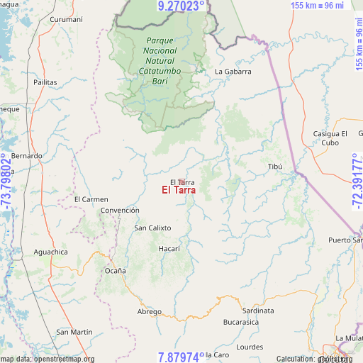
El Tarra GPS coordinates[2]
8° 34' 32.232" North, 73° 5' 41.604" West
| Map corner | latitude | longitude |
|---|---|---|
| Upper-left | 9.27023°, | -73.79802° |
| Center: | 8.57562°, | -73.09489° |
| Lower-right: | 7.87974°, | -72.39177° |
| Map W x H: | 154.6×154.6 km | = 96.1×96.1mi |
| max Lat: | 13.38166° ⇑15.7% North |
| El Tarra: | 8.57562° |
| min Lat: | ⇓84.3% South -4.21528° |
| min Long | El Tarra | max Long |
| -81.70636° | -73.09489° | -67.06996° |
| W 84.9%⇐ | ⇒15.1% E |
Elevation
Elevation of El Tarra is 197 m = 646 ft, and this is 952.3 m = 3124 ft below average elevation for this country.
| Max E: |
3342 m = 10965 ft | 74.6% |
| Avg. | 1149.3 m = 3771 ft | |
| El Tarra | 197 m = 646 ft | |
Min E: |
1 m = 3 ft | 25.4% |
See also: Colombia elevation on elevation.city.
Geographical zone
El Tarra is located in North Torrid zone (between Equator and Tropic of Cancer). Distance of Equator is 953.5 km =592.5 mi to South.| Distance of | km | miles | from El Tarra |
|---|---|---|---|
| North Pole | 9053.5 | 5625.6 | to North |
| Arctic Circle | 6447.7 | 4006.4 | to North |
| Tropic Cancer | 1652.4 | 1026.8 | to North |
| Equator | 953.5 | 592.5 | to South |


Nearby cities:
15 places around El Tarra: (largest is in red/bold)
• Aguachica
64.6 km =40.1 mi,  242°
242°
• Bucarasica
64.6 km =40.1 mi,  156°
156°
• Convención
29.2 km =18.1 mi,  246°
246°
• El Carmen
39.5 km =24.5 mi,  259°
259°
• González
37.6 km =23.4 mi, 236°
• Hacarí
28.7 km =17.8 mi,  191°
191°
• La Playa
43.3 km =26.9 mi,  201°
201°
• Ocaña
47.3 km =29.4 mi,  217°
217°
• Pelaya
63.9 km =39.7 mi,  281°
281°
• Río de Oro
44.9 km =27.9 mi,  225°
225°
• San Calixto
22.9 km =14.2 mi,  212°
212°
• Sardinata
63.6 km =39.5 mi,  149°
149°
• Teorama
26.4 km =16.4 mi, 234°
• Tibú
40.1 km =24.9 mi,  79°
79°
• Ábrego
56.7 km =35.2 mi, 194°
Sources, notices
• [Note1] Compared only with cities in Colombia existing in our database
• [Src1] Map data: © OpenStreetMap contributors (CC-BY-SA)
• [Src2] Other city data from geonames.org with taken over terms of usage.
• [Src3] Geographical zone / Annual Mean Temperature by Robert A. Rohde @ Wikipedia
