González geodata
González (Cesar) is a seat of a second-order administrative division; located in Colombia in America/Bogota (GMT-5) time zone. With population of 5,634 people, there are 469 cities with bigger population in this country. Compared to other cities in Colombia, 83.1% of cities are located further ↓South; 78.1% of cities are located further ←West and 55.7% of cities have lower elevation than González. Note1


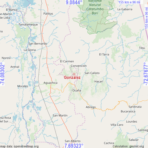
González GPS coordinates[2]
8° 23' 21.984" North, 73° 22' 47.604" West
| Map corner | latitude | longitude |
|---|---|---|
| Upper-left | 9.0844°, | -74.08302° |
| Center: | 8.38944°, | -73.37989° |
| Lower-right: | 7.69323°, | -72.67677° |
| Map W x H: | 154.7×154.7 km | = 96.1×96.1mi |
| max Lat: | 13.38166° ⇑16.9% North |
| González: | 8.38944° |
| min Lat: | ⇓83.1% South -4.21528° |
| min Long | González | max Long |
| -81.70636° | -73.37989° | -67.06996° |
| W 78.1%⇐ | ⇒21.9% E |
Elevation
Elevation of González is 1309 m = 4295 ft, and this is 159.7 m = 524 ft above average elevation for this country.
| Max E: |
3342 m = 10965 ft | 44.3% |
| González | 1309 m 4295 ft | |
| Avg. | 1149.3 m = 3771 ft | |
Min E: |
1 m = 3 ft | 55.7% |
See also: Colombia elevation on elevation.city.
Geographical zone
González is located in North Torrid zone (between Equator and Tropic of Cancer). Distance of Equator is 932.8 km =579.6 mi to South.| Distance of | km | miles | from González |
|---|---|---|---|
| North Pole | 9074.2 | 5638.4 | to North |
| Arctic Circle | 6468.4 | 4019.3 | to North |
| Tropic Cancer | 1673.1 | 1039.6 | to North |
| Equator | 932.8 | 579.6 | to South |


Nearby cities:
15 places around González: (largest is in red/bold)
• Aguachica
27.6 km =17.1 mi,  250°
250°
• Convención
10 km =6.2 mi,  27°
27°
• El Carmen
15.4 km =9.6 mi,  331°
331°
• El Tarra
37.6 km =23.4 mi,  56°
56°
• Gamarra
40.6 km =25.2 mi,  259°
259°
• Hacarí
26.5 km =16.5 mi,  106°
106°
• La Gloria
53 km =32.9 mi,  298°
298°
• La Playa
25 km =15.5 mi,  141°
141°
• Ocaña
17.1 km =10.6 mi,  171°
171°
• Pelaya
45.6 km =28.3 mi,  316°
316°
• Río de Oro
10.9 km =6.8 mi,  182°
182°
• San Calixto
19 km =11.8 mi,  85°
85°
• San Martín
45.5 km =28.3 mi,  198°
198°
• Teorama
11.2 km =7 mi, 62°
• Ábrego
38.6 km =24 mi,  152°
152°
Sources, notices
• [Note1] Compared only with cities in Colombia existing in our database
• [Src1] Map data: © OpenStreetMap contributors (CC-BY-SA)
• [Src2] Other city data from geonames.org with taken over terms of usage.
• [Src3] Geographical zone / Annual Mean Temperature by Robert A. Rohde @ Wikipedia
