Pore geodata
Pore (Casanare) is a seat of a second-order administrative division; located in Colombia in America/Bogota (GMT-5) time zone. With population of 4,133 people, there are 573 cities with bigger population in this country. Compared to other cities in Colombia, 54.5% of cities are located further ↓South; 97.9% of cities are located further ←West and 70.4% of cities have higher elevation than Pore. Note1


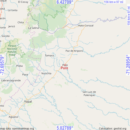
Pore GPS coordinates[2]
5° 43' 40.512" North, 71° 59' 33.576" West
| Map corner | latitude | longitude |
|---|---|---|
| Upper-left | 6.42709°, | -72.69579° |
| Center: | 5.72792°, | -71.99266° |
| Lower-right: | 5.02789°, | -71.28954° |
| Map W x H: | 155.6×155.6 km | = 96.7×96.7mi |
| max Lat: | 13.38166° ⇑45.5% North |
| Pore: | 5.72792° |
| min Lat: | ⇓54.5% South -4.21528° |
| min Long | Pore | max Long |
| -81.70636° | -71.99266° | -67.06996° |
| W 97.9%⇐ | ⇒2.1% E |
Elevation
Elevation of Pore is 287 m = 942 ft, and this is 862.3 m = 2829 ft below average elevation for this country.
| Max E: |
3342 m = 10965 ft | 70.4% |
| Avg. | 1149.3 m = 3771 ft | |
| Pore | 287 m = 942 ft | |
Min E: |
1 m = 3 ft | 29.6% |
See also: Colombia elevation on elevation.city.
Geographical zone
Pore is located in North Torrid zone (between Equator and Tropic of Cancer). Distance of Equator is 636.9 km =395.8 mi to South.| Distance of | km | miles | from Pore |
|---|---|---|---|
| North Pole | 9370.2 | 5822.4 | to North |
| Arctic Circle | 6764.3 | 4203.1 | to North |
| Tropic Cancer | 1969 | 1223.5 | to North |
| Equator | 636.9 | 395.8 | to South |


Nearby cities:
15 places around Pore: (largest is in red/bold)
• Chita
74.2 km =46.1 mi,  313°
313°
• Jericó
79 km =49.1 mi, 306°
• La Salina
59 km =36.7 mi,  319°
319°
• Labranzagrande
67 km =41.6 mi,  254°
254°
• Municipio Hato Corozal
54 km =33.6 mi,  27°
27°
• Nunchía
24.7 km =15.3 mi, 245°
• Paya
49 km =30.4 mi,  256°
256°
• Paz de Ariporo
20.4 km =12.7 mi, 33°
• Pisba
54.6 km =33.9 mi,  269°
269°
• San Luis de Palenque
44.7 km =27.8 mi,  139°
139°
• Sácama
50.1 km =31.1 mi,  325°
325°
• Trinidad
51 km =31.7 mi,  134°
134°
• Támara
22 km =13.7 mi,  301°
301°
• Villanueva
49.5 km =30.8 mi,  176°
176°
• Yopal
62.2 km =38.6 mi,  225°
225°
Sources, notices
• [Note1] Compared only with cities in Colombia existing in our database
• [Src1] Map data: © OpenStreetMap contributors (CC-BY-SA)
• [Src2] Other city data from geonames.org with taken over terms of usage.
• [Src3] Geographical zone / Annual Mean Temperature by Robert A. Rohde @ Wikipedia
