Isnos geodata
Isnos (Huila) is a populated place; located in Colombia in America/Bogota (GMT-5) time zone. With population of 5,185 people, there are 497 cities with bigger population in this country. Compared to other cities in Colombia, 90.5% of cities are located further ↑North; 83.6% of cities are located further →East and 73.7% of cities have lower elevation than Isnos. Note1


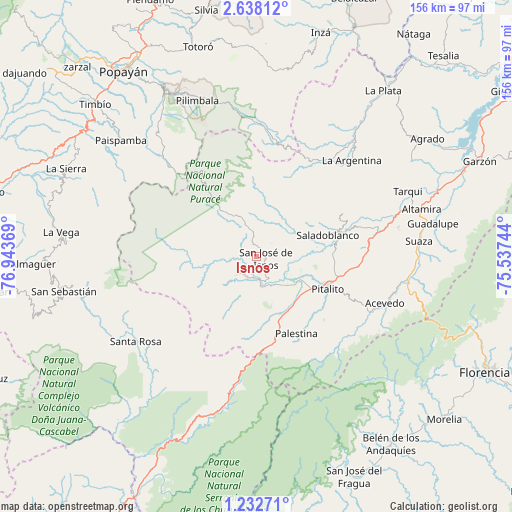
Isnos GPS coordinates[2]
1° 56' 8.016" North, 76° 14' 26.016" West
| Map corner | latitude | longitude |
|---|---|---|
| Upper-left | 2.63812°, | -76.94369° |
| Center: | 1.93556°, | -76.24056° |
| Lower-right: | 1.23271°, | -75.53744° |
| Map W x H: | 156.3×156.3 km | = 97.1×97.1mi |
| max Lat: | 13.38166° ⇑90.5% North |
| Isnos: | 1.93556° |
| min Lat: | ⇓9.5% South -4.21528° |
| min Long | Isnos | max Long |
| -81.70636° | -76.24056° | -67.06996° |
| W 16.4%⇐ | ⇒83.6% E |
Elevation
Elevation of Isnos is 1806 m = 5925 ft, and this is 656.7 m = 2155 ft above average elevation for this country.
| Max E: |
3342 m = 10965 ft | 26.3% |
| Isnos | 1806 m 5925 ft | |
| Avg. | 1149.3 m = 3771 ft | |
Min E: |
1 m = 3 ft | 73.7% |
See also: Colombia elevation on elevation.city.
Geographical zone
Isnos is located in North Torrid zone (between Equator and Tropic of Cancer). Distance of Equator is 215.2 km =133.7 mi to South.| Distance of | km | miles | from Isnos |
|---|---|---|---|
| North Pole | 9791.8 | 6084.3 | to North |
| Arctic Circle | 7186 | 4465.2 | to North |
| Tropic Cancer | 2390.7 | 1485.5 | to North |
| Equator | 215.2 | 133.7 | to South |


Nearby cities:
15 places around Isnos: (largest is in red/bold)
• Acevedo
41.6 km =25.8 mi,  110°
110°
• Altamira
52.3 km =32.5 mi,  74°
74°
• Coconuco
53.4 km =33.2 mi,  327°
327°
• Elías
34.5 km =21.4 mi,  75°
75°
• Isnos
3.4 km =2.1 mi,  103°
103°
• La Argentina
41.1 km =25.5 mi,  44°
44°
• Oporapa
28.9 km =18 mi, 70°
• Palestina
26.4 km =16.4 mi,  153°
153°
• Pitalito
23 km =14.3 mi, 113°
• Saladoblanco
22.8 km =14.2 mi, 73°
• San Agustín
7 km =4.3 mi,  205°
205°
• Santa Rosa
45.2 km =28.1 mi,  235°
235°
• Suaza
49.8 km =30.9 mi, 84°
• Tarqui
50.3 km =31.3 mi, 66°
• Timaná
34.6 km =21.5 mi, 83°
Sources, notices
• [Note1] Compared only with cities in Colombia existing in our database
• [Src1] Map data: © OpenStreetMap contributors (CC-BY-SA)
• [Src2] Other city data from geonames.org with taken over terms of usage.
• [Src3] Geographical zone / Annual Mean Temperature by Robert A. Rohde @ Wikipedia
