San Agustín geodata
San Agustín (Huila) is a populated place; located in Colombia in America/Bogota (GMT-5) time zone. With population of 9,481 people, there are 323 cities with bigger population in this country. Compared to other cities in Colombia, 91% of cities are located further ↑North; 84.1% of cities are located further →East and 66.5% of cities have lower elevation than San Agustín. Note1


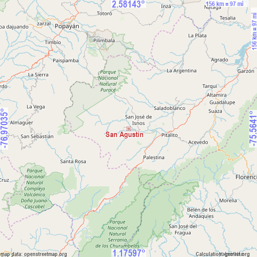
San Agustín GPS coordinates[2]
1° 52' 43.824" North, 76° 16' 1.992" West
| Map corner | latitude | longitude |
|---|---|---|
| Upper-left | 2.58143°, | -76.97035° |
| Center: | 1.87884°, | -76.26722° |
| Lower-right: | 1.17597°, | -75.5641° |
| Map W x H: | 156.3×156.3 km | = 97.1×97.1mi |
| max Lat: | 13.38166° ⇑91% North |
| San Agustín: | 1.87884° |
| min Lat: | ⇓9% South -4.21528° |
| min Long | San Agustín | max Long |
| -81.70636° | -76.26722° | -67.06996° |
| W 15.9%⇐ | ⇒84.1% E |
Elevation
Elevation of San Agustín is 1632 m = 5354 ft, and this is 482.7 m = 1584 ft above average elevation for this country.
| Max E: |
3342 m = 10965 ft | 33.5% |
| San Agustín | 1632 m 5354 ft | |
| Avg. | 1149.3 m = 3771 ft | |
Min E: |
1 m = 3 ft | 66.5% |
See also: Colombia elevation on elevation.city.
Geographical zone
San Agustín is located in North Torrid zone (between Equator and Tropic of Cancer). Distance of Equator is 208.9 km =129.8 mi to South.| Distance of | km | miles | from San Agustín |
|---|---|---|---|
| North Pole | 9798.2 | 6088.3 | to North |
| Arctic Circle | 7192.3 | 4469.1 | to North |
| Tropic Cancer | 2397 | 1489.4 | to North |
| Equator | 208.9 | 129.8 | to South |


Nearby cities:
15 places around San Agustín: (largest is in red/bold)
• Acevedo
42.7 km =26.5 mi,  101°
101°
• Elías
39.3 km =24.4 mi,  67°
67°
• Isnos
7 km =4.3 mi,  25°
25°
• Isnos
8.4 km =5.2 mi,  48°
48°
• La Argentina
47.7 km =29.6 mi,  42°
42°
• Oporapa
34.2 km =21.3 mi,  61°
61°
• Paispamba
56.6 km =35.2 mi,  317°
317°
• Palestina
22.7 km =14.1 mi,  139°
139°
• Pitalito
24.2 km =15 mi, 96°
• Saladoblanco
27.9 km =17.3 mi, 63°
• San Sebastián
56.3 km =35 mi,  265°
265°
• Santa Rosa
39.3 km =24.4 mi,  240°
240°
• Suaza
53.6 km =33.3 mi,  78°
78°
• Tarqui
55.7 km =34.6 mi, 62°
• Timaná
38.7 km =24 mi, 74°
Sources, notices
• [Note1] Compared only with cities in Colombia existing in our database
• [Src1] Map data: © OpenStreetMap contributors (CC-BY-SA)
• [Src2] Other city data from geonames.org with taken over terms of usage.
• [Src3] Geographical zone / Annual Mean Temperature by Robert A. Rohde @ Wikipedia
