Guayabal geodata
Guayabal (Tolima) is a seat of a second-order administrative division; located in Colombia in America/Bogota (GMT-5) time zone. With population of 5,339 people, there are 487 cities with bigger population in this country. Compared to other cities in Colombia, 61.3% of cities are located further ↑North; 51.4% of cities are located further →East and 70.7% of cities have higher elevation than Guayabal. Note1


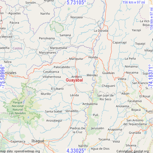
Guayabal GPS coordinates[2]
5° 1' 51.708" North, 74° 53' 12.588" West
| Map corner | latitude | longitude |
|---|---|---|
| Upper-left | 5.73105°, | -75.58996° |
| Center: | 5.03103°, | -74.88683° |
| Lower-right: | 4.33025°, | -74.18371° |
| Map W x H: | 155.8×155.8 km | = 96.8×96.8mi |
| max Lat: | 13.38166° ⇑61.3% North |
| Guayabal: | 5.03103° |
| min Lat: | ⇓38.7% South -4.21528° |
| min Long | Guayabal | max Long |
| -81.70636° | -74.88683° | -67.06996° |
| W 48.6%⇐ | ⇒51.4% E |
Elevation
Elevation of Guayabal is 280 m = 919 ft, and this is 869.3 m = 2852 ft below average elevation for this country.
| Max E: |
3342 m = 10965 ft | 70.7% |
| Avg. | 1149.3 m = 3771 ft | |
| Guayabal | 280 m = 919 ft | |
Min E: |
1 m = 3 ft | 29.3% |
See also: Colombia elevation on elevation.city.
Geographical zone
Guayabal is located in North Torrid zone (between Equator and Tropic of Cancer). Distance of Equator is 559.4 km =347.6 mi to South.| Distance of | km | miles | from Guayabal |
|---|---|---|---|
| North Pole | 9447.7 | 5870.5 | to North |
| Arctic Circle | 6841.8 | 4251.3 | to North |
| Tropic Cancer | 2046.5 | 1271.6 | to North |
| Equator | 559.4 | 347.6 | to South |


Nearby cities:
15 places around Guayabal: (largest is in red/bold)
• Ambalema
30.7 km =19.1 mi,  153°
153°
• Armero-Guyabal
7.3 km =4.5 mi,  194°
194°
• Beltrán
30.1 km =18.7 mi, 147°
• Casabianca
26.4 km =16.4 mi,  281°
281°
• Falan
12.6 km =7.8 mi,  325°
325°
• Fresno
21.4 km =13.3 mi,  309°
309°
• Frías
13.5 km =8.4 mi,  269°
269°
• Honda
25.9 km =16.1 mi,  40°
40°
• Lérida
18.9 km =11.7 mi, 187°
• Líbano
22.9 km =14.2 mi,  238°
238°
• Padua
30.3 km =18.8 mi,  292°
292°
• Palocabildo
17.3 km =10.7 mi,  303°
303°
• Puerto Bogotá
25.8 km =16 mi, 43°
• San Sebastián de Mariquita
18.7 km =11.6 mi,  357°
357°
• Villahermosa
25.4 km =15.8 mi, 269°
Sources, notices
• [Note1] Compared only with cities in Colombia existing in our database
• [Src1] Map data: © OpenStreetMap contributors (CC-BY-SA)
• [Src2] Other city data from geonames.org with taken over terms of usage.
• [Src3] Geographical zone / Annual Mean Temperature by Robert A. Rohde @ Wikipedia
