Frías geodata
Frías (Tolima) is a populated place; located in Colombia in America/Bogota (GMT-5) time zone. With population of 1,215 people, there are 911 cities with bigger population in this country. Compared to other cities in Colombia, 61.5% of cities are located further ↑North; 54.2% of cities are located further →East and 56% of cities have lower elevation than Frías. Note1


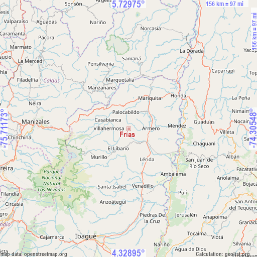
Frías GPS coordinates[2]
5° 1' 47.028" North, 75° 0' 30.96" West
| Map corner | latitude | longitude |
|---|---|---|
| Upper-left | 5.72975°, | -75.71173° |
| Center: | 5.02973°, | -75.0086° |
| Lower-right: | 4.32895°, | -74.30548° |
| Map W x H: | 155.8×155.8 km | = 96.8×96.8mi |
| max Lat: | 13.38166° ⇑61.5% North |
| Frías: | 5.02973° |
| min Lat: | ⇓38.5% South -4.21528° |
| min Long | Frías | max Long |
| -81.70636° | -75.0086° | -67.06996° |
| W 45.8%⇐ | ⇒54.2% E |
Elevation
Elevation of Frías is 1321 m = 4334 ft, and this is 171.7 m = 563 ft above average elevation for this country.
| Max E: |
3342 m = 10965 ft | 44% |
| Frías | 1321 m 4334 ft | |
| Avg. | 1149.3 m = 3771 ft | |
Min E: |
1 m = 3 ft | 56% |
See also: Colombia elevation on elevation.city.
Geographical zone
Frías is located in North Torrid zone (between Equator and Tropic of Cancer). Distance of Equator is 559.3 km =347.5 mi to South.| Distance of | km | miles | from Frías |
|---|---|---|---|
| North Pole | 9447.8 | 5870.6 | to North |
| Arctic Circle | 6841.9 | 4251.4 | to North |
| Tropic Cancer | 2046.7 | 1271.8 | to North |
| Equator | 559.3 | 347.5 | to South |


Nearby cities:
15 places around Frías: (largest is in red/bold)
• Armero-Guyabal
13.6 km =8.5 mi,  120°
120°
• Casabianca
13.6 km =8.5 mi,  294°
294°
• Falan
12.2 km =7.6 mi,  31°
31°
• Fresno
14 km =8.7 mi,  347°
347°
• Guayabal
13.5 km =8.4 mi,  89°
89°
• Herveo
19.3 km =12 mi, 286°
• Junín
27.4 km =17 mi,  181°
181°
• Lérida
21.6 km =13.4 mi,  149°
149°
• Líbano
13.4 km =8.3 mi,  206°
206°
• Manzanares
29.7 km =18.5 mi,  327°
327°
• Murillo
25 km =15.5 mi,  226°
226°
• Padua
18.6 km =11.6 mi,  308°
308°
• Palocabildo
9.8 km =6.1 mi, 354°
• San Sebastián de Mariquita
22.8 km =14.2 mi, 34°
• Villahermosa
11.9 km =7.4 mi,  270°
270°
Sources, notices
• [Note1] Compared only with cities in Colombia existing in our database
• [Src1] Map data: © OpenStreetMap contributors (CC-BY-SA)
• [Src2] Other city data from geonames.org with taken over terms of usage.
• [Src3] Geographical zone / Annual Mean Temperature by Robert A. Rohde @ Wikipedia
