Herveo geodata
Herveo (Tolima) is a seat of a second-order administrative division; located in Colombia in America/Bogota (GMT-5) time zone. With population of 3,490 people, there are 634 cities with bigger population in this country. Compared to other cities in Colombia, 60% of cities are located further ↑North; 58.8% of cities are located further →East and 78.1% of cities have lower elevation than Herveo. Note1


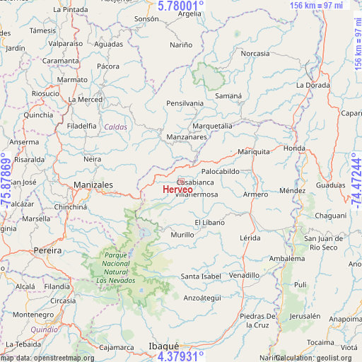
Herveo GPS coordinates[2]
5° 4' 48.144" North, 75° 10' 32.016" West
| Map corner | latitude | longitude |
|---|---|---|
| Upper-left | 5.78001°, | -75.87869° |
| Center: | 5.08004°, | -75.17556° |
| Lower-right: | 4.37931°, | -74.47244° |
| Map W x H: | 155.7×155.7 km | = 96.7×96.7mi |
| max Lat: | 13.38166° ⇑60% North |
| Herveo: | 5.08004° |
| min Lat: | ⇓40% South -4.21528° |
| min Long | Herveo | max Long |
| -81.70636° | -75.17556° | -67.06996° |
| W 41.2%⇐ | ⇒58.8% E |
Elevation
Elevation of Herveo is 1976 m = 6483 ft, and this is 826.7 m = 2712 ft above average elevation for this country.
| Max E: |
3342 m = 10965 ft | 21.9% |
| Herveo | 1976 m 6483 ft | |
| Avg. | 1149.3 m = 3771 ft | |
Min E: |
1 m = 3 ft | 78.1% |
See also: Colombia elevation on elevation.city.
Geographical zone
Herveo is located in North Torrid zone (between Equator and Tropic of Cancer). Distance of Equator is 564.8 km =351 mi to South.| Distance of | km | miles | from Herveo |
|---|---|---|---|
| North Pole | 9442.2 | 5867.1 | to North |
| Arctic Circle | 6836.3 | 4247.9 | to North |
| Tropic Cancer | 2041.1 | 1268.3 | to North |
| Equator | 564.8 | 351 | to South |


Nearby cities:
15 places around Herveo: (largest is in red/bold)
• Armero-Guyabal
32.7 km =20.3 mi,  112°
112°
• Casabianca
6.1 km =3.8 mi,  90°
90°
• Falan
25.3 km =15.7 mi,  78°
78°
• Fresno
17.4 km =10.8 mi,  62°
62°
• Frías
19.3 km =12 mi, 106°
• Guayabal
32.4 km =20.1 mi,  99°
99°
• Líbano
21.6 km =13.4 mi,  144°
144°
• Manzanares
19.5 km =12.1 mi,  7°
7°
• Marquetalia
27.5 km =17.1 mi,  29°
29°
• Marulanda
24.5 km =15.2 mi,  337°
337°
• Murillo
22.9 km =14.2 mi,  178°
178°
• Padua
7.2 km =4.5 mi, 33°
• Palocabildo
18 km =11.2 mi, 76°
• Pensilvania
33.8 km =21 mi,  2°
2°
• Villahermosa
8.6 km =5.3 mi,  129°
129°
Sources, notices
• [Note1] Compared only with cities in Colombia existing in our database
• [Src1] Map data: © OpenStreetMap contributors (CC-BY-SA)
• [Src2] Other city data from geonames.org with taken over terms of usage.
• [Src3] Geographical zone / Annual Mean Temperature by Robert A. Rohde @ Wikipedia
