Villanueva geodata
Villanueva (Casanare) is a populated place; located in Colombia in America/Bogota (GMT-5) time zone. With population of 20,032 people, there are 180 cities with bigger population in this country. Compared to other cities in Colombia, 55.3% of cities are located further ↑North; 97.9% of cities are located further ←West and 74.9% of cities have higher elevation than Villanueva. Note1


Villanueva GPS coordinates[2]
5° 16' 59.988" North, 71° 58' 0.012" West
| Map corner | latitude | longitude |
|---|---|---|
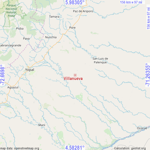
| Upper-left | 5.98305°, | -72.6698° |
| Center: | 5.28333°, | -71.96667° |
| Lower-right: | 4.58281°, | -71.26355° |
| Map W x H: | 155.7×155.7 km | = 96.7×96.7mi |
| max Lat: | 13.38166° ⇑55.3% North |
| Villanueva: | 5.28333° |
| min Lat: | ⇓44.7% South -4.21528° |
| min Long | Villanueva | max Long |
| -81.70636° | -71.96667° | -67.06996° |
| W 97.9%⇐ | ⇒2.1% E |
Elevation
Elevation of Villanueva is 185 m = 607 ft, and this is 964.3 m = 3164 ft below average elevation for this country.
| Max E: |
3342 m = 10965 ft | 74.9% |
| Avg. | 1149.3 m = 3771 ft | |
| Villanueva | 185 m = 607 ft | |
Min E: |
1 m = 3 ft | 25.1% |
See also: Colombia elevation on elevation.city.
Geographical zone
Villanueva is located in North Torrid zone (between Equator and Tropic of Cancer). Distance of Equator is 587.5 km =365.1 mi to South.| Distance of | km | miles | from Villanueva |
|---|---|---|---|
| North Pole | 9419.6 | 5853.1 | to North |
| Arctic Circle | 6813.7 | 4233.8 | to North |
| Tropic Cancer | 2018.5 | 1254.2 | to North |
| Equator | 587.5 | 365.1 | to South |


Nearby cities:
15 places around Villanueva: (largest is in red/bold)
• Aguazul
65.4 km =40.6 mi,  259°
259°
• Labranzagrande
74.1 km =46 mi,  294°
294°
• Maní
62.4 km =38.8 mi,  213°
213°
• Nunchía
46.7 km =29 mi,  327°
327°
• Pajarito
81.5 km =50.6 mi,  270°
270°
• Paya
63.2 km =39.3 mi,  306°
306°
• Paz de Ariporo
67 km =41.6 mi,  7°
7°
• Pisba
75.6 km =47 mi, 310°
• Pore
49.5 km =30.8 mi,  356°
356°
• Recetor
88.2 km =54.8 mi, 266°
• San Luis de Palenque
30.2 km =18.8 mi,  59°
59°
• Trinidad
36.5 km =22.7 mi,  67°
67°
• Támara
64.5 km =40.1 mi,  340°
340°
• Ubalá
86.8 km =53.9 mi,  226°
226°
• Yopal
47.9 km =29.8 mi,  277°
277°
Sources, notices
• [Note1] Compared only with cities in Colombia existing in our database
• [Src1] Map data: © OpenStreetMap contributors (CC-BY-SA)
• [Src2] Other city data from geonames.org with taken over terms of usage.
• [Src3] Geographical zone / Annual Mean Temperature by Robert A. Rohde @ Wikipedia
