Argelia geodata
Argelia (Cauca) is a seat of a second-order administrative division; located in Colombia in America/Bogota (GMT-5) time zone. With population of 4,262 people, there are 556 cities with bigger population in this country. Compared to other cities in Colombia, 88.6% of cities are located further ↑North; 94.3% of cities are located further →East and 53.7% of cities have lower elevation than Argelia. Note1


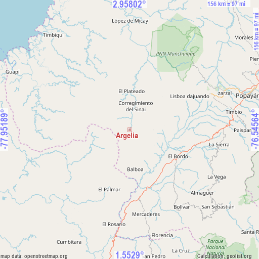
Argelia GPS coordinates[2]
2° 15' 20.268" North, 77° 14' 55.536" West
| Map corner | latitude | longitude |
|---|---|---|
| Upper-left | 2.95802°, | -77.95189° |
| Center: | 2.25563°, | -77.24876° |
| Lower-right: | 1.5529°, | -76.54564° |
| Map W x H: | 156.2×156.2 km | = 97.1×97.1mi |
| max Lat: | 13.38166° ⇑88.6% North |
| Argelia: | 2.25563° |
| min Lat: | ⇓11.4% South -4.21528° |
| min Long | Argelia | max Long |
| -81.70636° | -77.24876° | -67.06996° |
| W 5.7%⇐ | ⇒94.3% E |
Elevation
Elevation of Argelia is 1256 m = 4121 ft, and this is 106.7 m = 350 ft above average elevation for this country.
| Max E: |
3342 m = 10965 ft | 46.3% |
| Argelia | 1256 m 4121 ft | |
| Avg. | 1149.3 m = 3771 ft | |
Min E: |
1 m = 3 ft | 53.7% |
See also: Colombia elevation on elevation.city.
Geographical zone
Argelia is located in North Torrid zone (between Equator and Tropic of Cancer). Distance of Equator is 250.8 km =155.8 mi to South.| Distance of | km | miles | from Argelia |
|---|---|---|---|
| North Pole | 9756.3 | 6062.3 | to North |
| Arctic Circle | 7150.4 | 4443.1 | to North |
| Tropic Cancer | 2355.1 | 1463.4 | to North |
| Equator | 250.8 | 155.8 | to South |


Nearby cities:
15 places around Argelia: (largest is in red/bold)
• Almaguer
57.9 km =36 mi,  130°
130°
• Balboa
24 km =14.9 mi,  171°
171°
• Bolívar
55.7 km =34.6 mi,  146°
146°
• El Bordo
33.4 km =20.8 mi,  117°
117°
• El Rosario
57.7 km =35.9 mi,  189°
189°
• El Tambo
53.4 km =33.2 mi,  65°
65°
• La Sierra
54.7 km =34 mi,  99°
99°
• La Vega
59.3 km =36.8 mi, 118°
• Leiva
36.2 km =22.5 mi, 190°
• López
53.6 km =33.3 mi, 68°
• Mercaderes
51.2 km =31.8 mi, 170°
• Patía
30.1 km =18.7 mi, 133°
• Rosas
56.5 km =35.1 mi,  89°
89°
• Sucre
43.4 km =27 mi, 123°
• Villa Rica
52.9 km =32.9 mi,  57°
57°
Sources, notices
• [Note1] Compared only with cities in Colombia existing in our database
• [Src1] Map data: © OpenStreetMap contributors (CC-BY-SA)
• [Src2] Other city data from geonames.org with taken over terms of usage.
• [Src3] Geographical zone / Annual Mean Temperature by Robert A. Rohde @ Wikipedia
