Simijaca geodata
Simijaca (Cundinamarca) is a seat of a second-order administrative division; located in Colombia in America/Bogota (GMT-5) time zone. With population of 4,767 people, there are 527 cities with bigger population in this country. Compared to other cities in Colombia, 50.6% of cities are located further ↑North; 68.6% of cities are located further ←West and 91% of cities have lower elevation than Simijaca. Note1


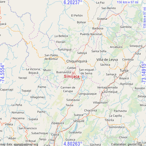
Simijaca GPS coordinates[2]
5° 30' 10.476" North, 73° 51' 8.172" West
| Map corner | latitude | longitude |
|---|---|---|
| Upper-left | 6.20237°, | -74.5554° |
| Center: | 5.50291°, | -73.85227° |
| Lower-right: | 4.80263°, | -73.14915° |
| Map W x H: | 155.6×155.6 km | = 96.7×96.7mi |
| max Lat: | 13.38166° ⇑50.6% North |
| Simijaca: | 5.50291° |
| min Lat: | ⇓49.4% South -4.21528° |
| min Long | Simijaca | max Long |
| -81.70636° | -73.85227° | -67.06996° |
| W 68.6%⇐ | ⇒31.4% E |
Elevation
Elevation of Simijaca is 2563 m = 8409 ft, and this is 1413.7 m = 4638 ft above average elevation for this country.
| Max E: |
3342 m = 10965 ft | 9% |
| Simijaca | 2563 m 8409 ft | |
| Avg. | 1149.3 m = 3771 ft | |
Min E: |
1 m = 3 ft | 91% |
See also: Colombia elevation on elevation.city.
Geographical zone
Simijaca is located in North Torrid zone (between Equator and Tropic of Cancer). Distance of Equator is 611.9 km =380.2 mi to South.| Distance of | km | miles | from Simijaca |
|---|---|---|---|
| North Pole | 9395.2 | 5837.9 | to North |
| Arctic Circle | 6789.3 | 4218.7 | to North |
| Tropic Cancer | 1994.1 | 1239.1 | to North |
| Equator | 611.9 | 380.2 | to South |


Nearby cities:
15 places around Simijaca: (largest is in red/bold)
• Briceño
21.8 km =13.5 mi,  340°
340°
• Buenavista
10.8 km =6.7 mi,  276°
276°
• Caldas
5.9 km =3.7 mi,  345°
345°
• Carmen de Carupa
18 km =11.2 mi,  197°
197°
• Chiquinquirá
13.2 km =8.2 mi,  16°
16°
• Coper
21.4 km =13.3 mi,  262°
262°
• Fúquene
12.6 km =7.8 mi,  150°
150°
• Guachetá
22.6 km =14 mi,  125°
125°
• Maripí
18.1 km =11.2 mi,  287°
287°
• Pauna
22.5 km =14 mi,  320°
320°
• Saboyá
23.4 km =14.5 mi, 23°
• San Miguel de Sema
14.5 km =9 mi,  83°
83°
• Susa
7.1 km =4.4 mi,  143°
143°
• Tinjacá
24.5 km =15.2 mi,  69°
69°
• Villa de San Diego de Ubaté
21.9 km =13.6 mi,  169°
169°
Sources, notices
• [Note1] Compared only with cities in Colombia existing in our database
• [Src1] Map data: © OpenStreetMap contributors (CC-BY-SA)
• [Src2] Other city data from geonames.org with taken over terms of usage.
• [Src3] Geographical zone / Annual Mean Temperature by Robert A. Rohde @ Wikipedia
