Fúquene geodata
Fúquene (Cundinamarca) is a seat of a second-order administrative division; located in Colombia in America/Bogota (GMT-5) time zone. With population of 563 people, there are 1021 cities with bigger population in this country. Compared to other cities in Colombia, 52.4% of cities are located further ↑North; 70.1% of cities are located further ←West and 97.9% of cities have lower elevation than Fúquene. Note1


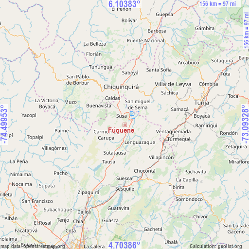
Fúquene GPS coordinates[2]
5° 24' 15.3" North, 73° 47' 47.04" West
| Map corner | latitude | longitude |
|---|---|---|
| Upper-left | 6.10383°, | -74.49953° |
| Center: | 5.40425°, | -73.7964° |
| Lower-right: | 4.70386°, | -73.09328° |
| Map W x H: | 155.7×155.7 km | = 96.7×96.7mi |
| max Lat: | 13.38166° ⇑52.4% North |
| Fúquene: | 5.40425° |
| min Lat: | ⇓47.6% South -4.21528° |
| min Long | Fúquene | max Long |
| -81.70636° | -73.7964° | -67.06996° |
| W 70.1%⇐ | ⇒29.9% E |
Elevation
Elevation of Fúquene is 2866 m = 9403 ft, and this is 1716.7 m = 5632 ft above average elevation for this country.
| Max E: |
3342 m = 10965 ft | 2.1% |
| Fúquene | 2866 m 9403 ft | |
| Avg. | 1149.3 m = 3771 ft | |
Min E: |
1 m = 3 ft | 97.9% |
See also: Colombia elevation on elevation.city.
Geographical zone
Fúquene is located in North Torrid zone (between Equator and Tropic of Cancer). Distance of Equator is 600.9 km =373.4 mi to South.| Distance of | km | miles | from Fúquene |
|---|---|---|---|
| North Pole | 9406.2 | 5844.7 | to North |
| Arctic Circle | 6800.3 | 4225.5 | to North |
| Tropic Cancer | 2005 | 1245.8 | to North |
| Equator | 600.9 | 373.4 | to South |


Nearby cities:
15 places around Fúquene: (largest is in red/bold)
• Buenavista
20.8 km =12.9 mi,  305°
305°
• Caldas
18.4 km =11.4 mi,  335°
335°
• Carmen de Carupa
13.2 km =8.2 mi,  242°
242°
• Chiquinquirá
23.7 km =14.7 mi,  354°
354°
• Cucunubá
17.5 km =10.9 mi,  168°
168°
• Guachetá
12.4 km =7.7 mi,  100°
100°
• La Mesa
20.3 km =12.6 mi,  221°
221°
• Lenguazaque
14.3 km =8.9 mi,  138°
138°
• Ráquira
23.5 km =14.6 mi,  50°
50°
• San Miguel de Sema
15.1 km =9.4 mi,  32°
32°
• Simijaca
12.6 km =7.8 mi,  330°
330°
• Susa
5.7 km =3.5 mi, 339°
• Sutatausa
18.5 km =11.5 mi,  199°
199°
• Tausa
25.1 km =15.6 mi, 204°
• Villa de San Diego de Ubaté
10.8 km =6.7 mi,  191°
191°
Sources, notices
• [Note1] Compared only with cities in Colombia existing in our database
• [Src1] Map data: © OpenStreetMap contributors (CC-BY-SA)
• [Src2] Other city data from geonames.org with taken over terms of usage.
• [Src3] Geographical zone / Annual Mean Temperature by Robert A. Rohde @ Wikipedia
